The ‘2018 Tour of Britain’ Leg Four – Morvich


Spectacular surrounds at Morvich Caravan Park.

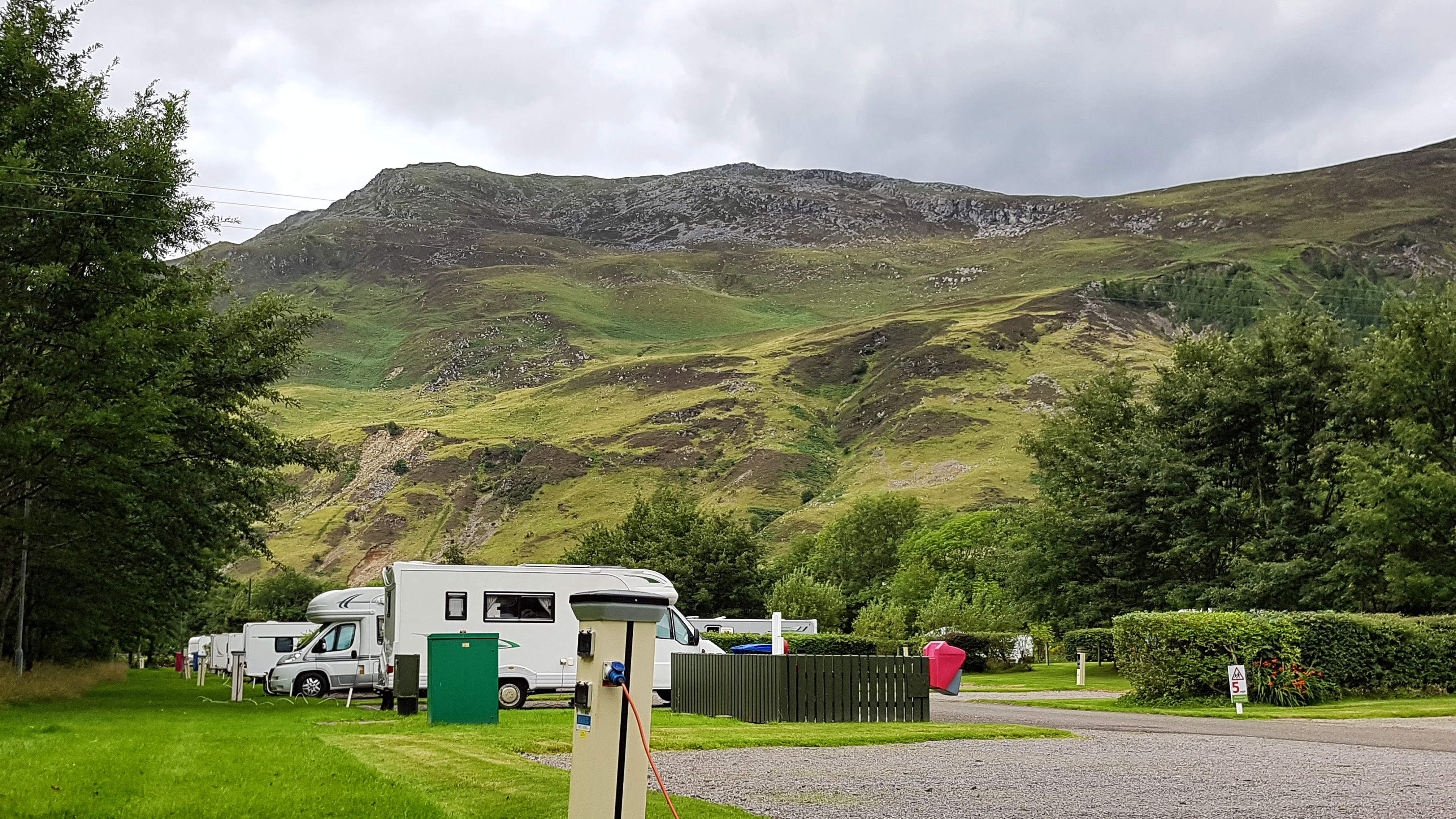
Morvich is a very small highland settlement within land owned by the Scottish National Trust consisting of no more than a few houses, a youth hostel or two, a mountain rescue centre and a Caravan Park in the Highlands of Scotland on the southern edge of Loch Duich.

Loch Duich from the village of Morvich.

Morvich is very close to the A87 which heads north to the Isle of Skye and other popular tourist destinations. it is also a popular base for hiking.

Heading to the The Old Man of Storr on the Isle of Skye.
The Old Man of Storr on the Isle of Skye – the best we saw of it on a very cloudy day.

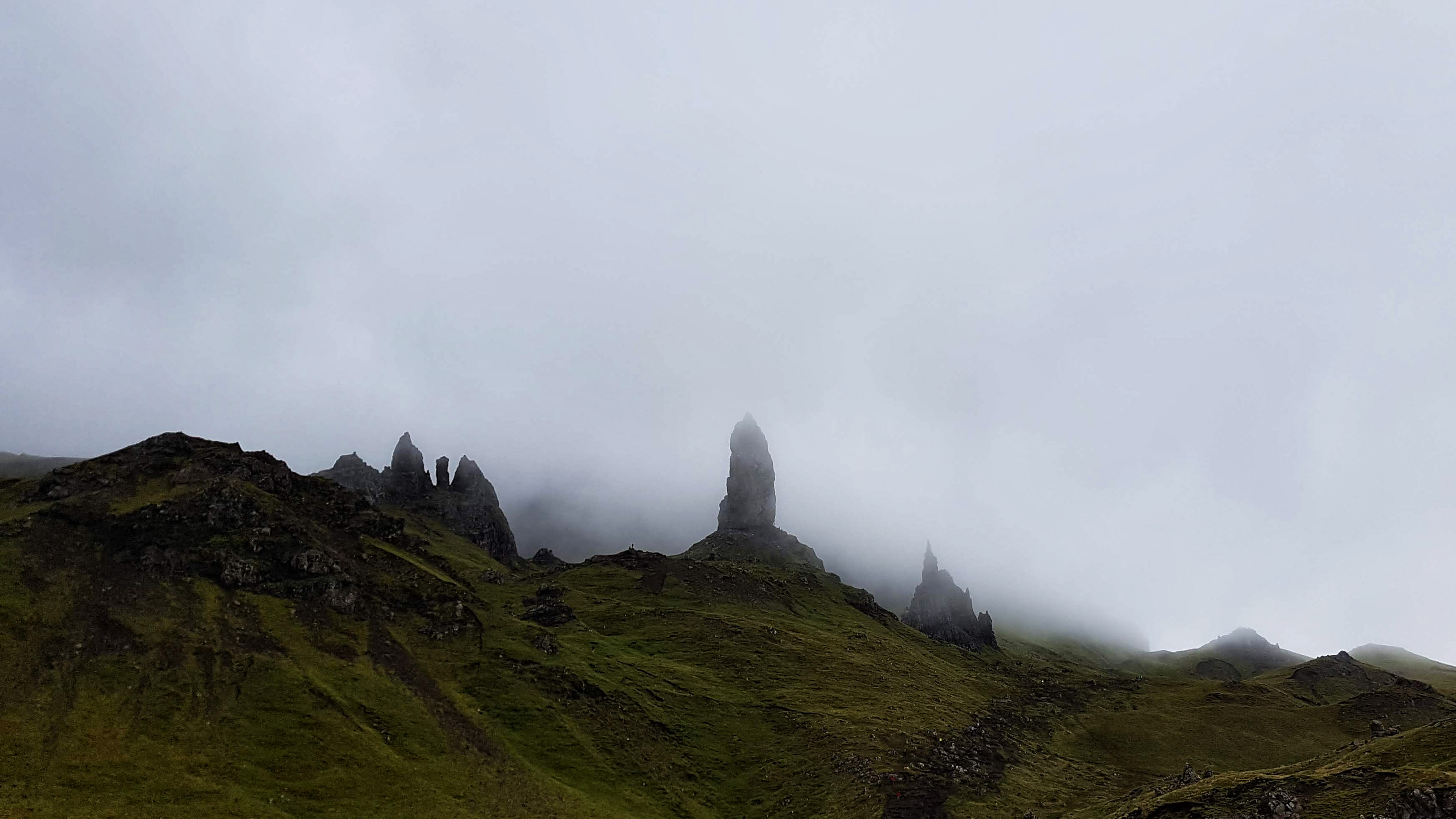
The Highlands is renowned for its climate that helps keep the grass lush and green and the lochs full of water. While it was noticeable how scorched much of the grass looked and how low the lochs appeared, the weather was mostly cloudy and sometimes wet on our visit – which is what we half expected, but was a touch disappointed nonetheless.

Plockton on a wet, drab afternoon.

Day 10 – Saturday 11th August 2018 – Almost Solitude 👌

This was a run I was fearing and looking forward to in equal measure. The opportunity to run in the spectacular surrounds of the Highlands was a thrilling prospect. The thought of having to get my body up and active after a 180 mile drive towing a caravan on some of the more demanding A roads on these isles was less than attractive. Having done the drive, set up the caravan and had lunch I was ready to collapse. But there was a run to be done and so I changed into my kit and off I headed.

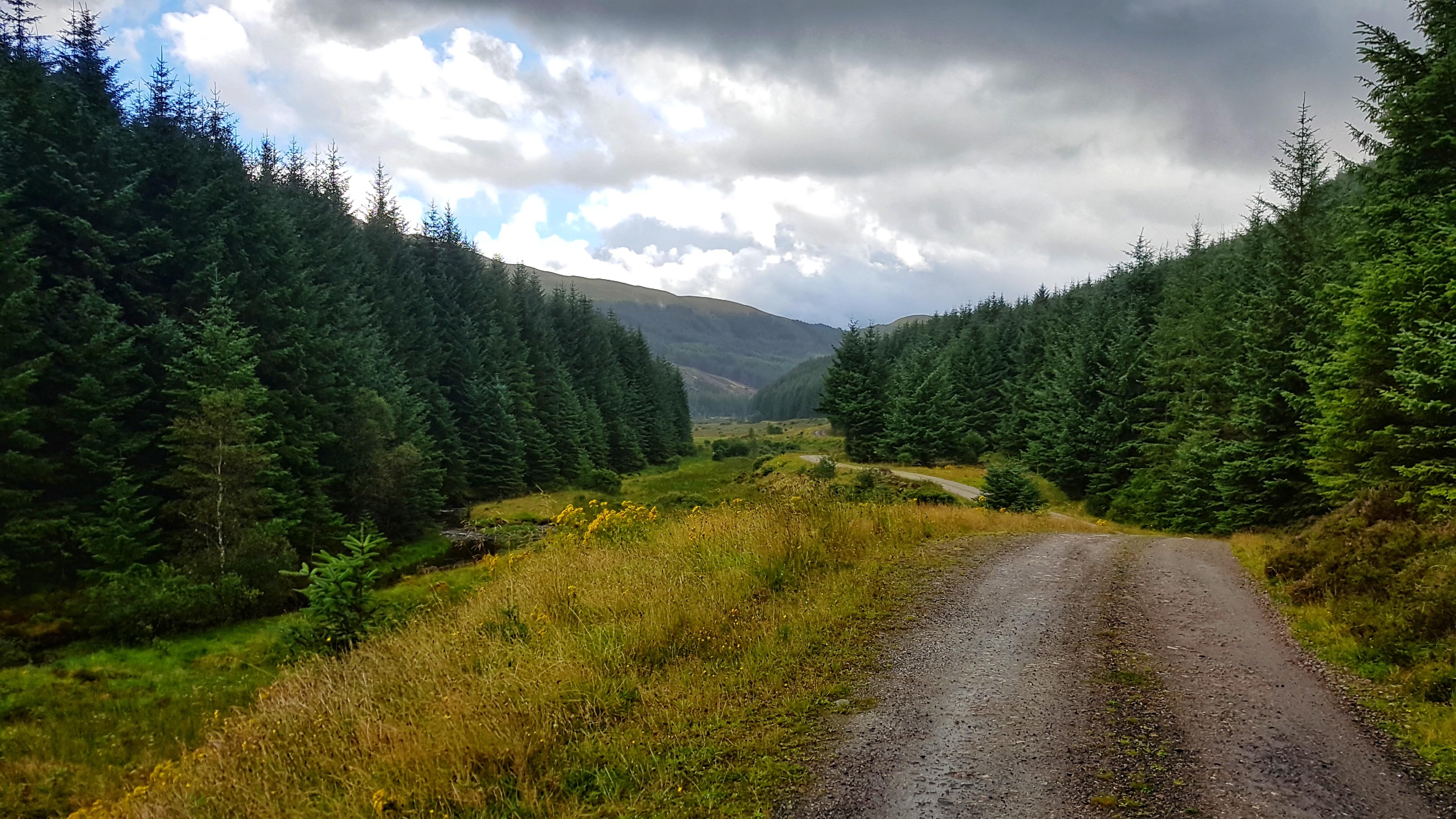
I’d already decided for my first run in the Highlands I was going to do an out and back on a track that appeared to run for several miles to nowhere in particular except for a building that was marked on Google Maps. Fearing some really tired legs I was pleasantly surprised that the opening mile was a not too slow 7:35. I was a touch disappointed to see the road turn into a gravel track (as I predicted) and then stop at a cul-de-sac of two houses. A quick inspection on the Google Maps showed that the track I wanted I’d missed (It was a gated bridle path I’d ignored a little while earlier). Heading back I felt my guts churn in a not pleasant way so I opted to head back to the Caravan Park to use the facilities and begin the run afresh.

The beautiful trail running from Morvinch.

Feeling much better and a little lighter I resumed the run. Mile two was a 6:39 which was really quite unexpected. Finding the correct bridle path this time I set off on what turned out to be three and a half miles of almost pure solitude and pure bliss.

Spectacular views on the trail from Morvich. (Not a Strava picture)

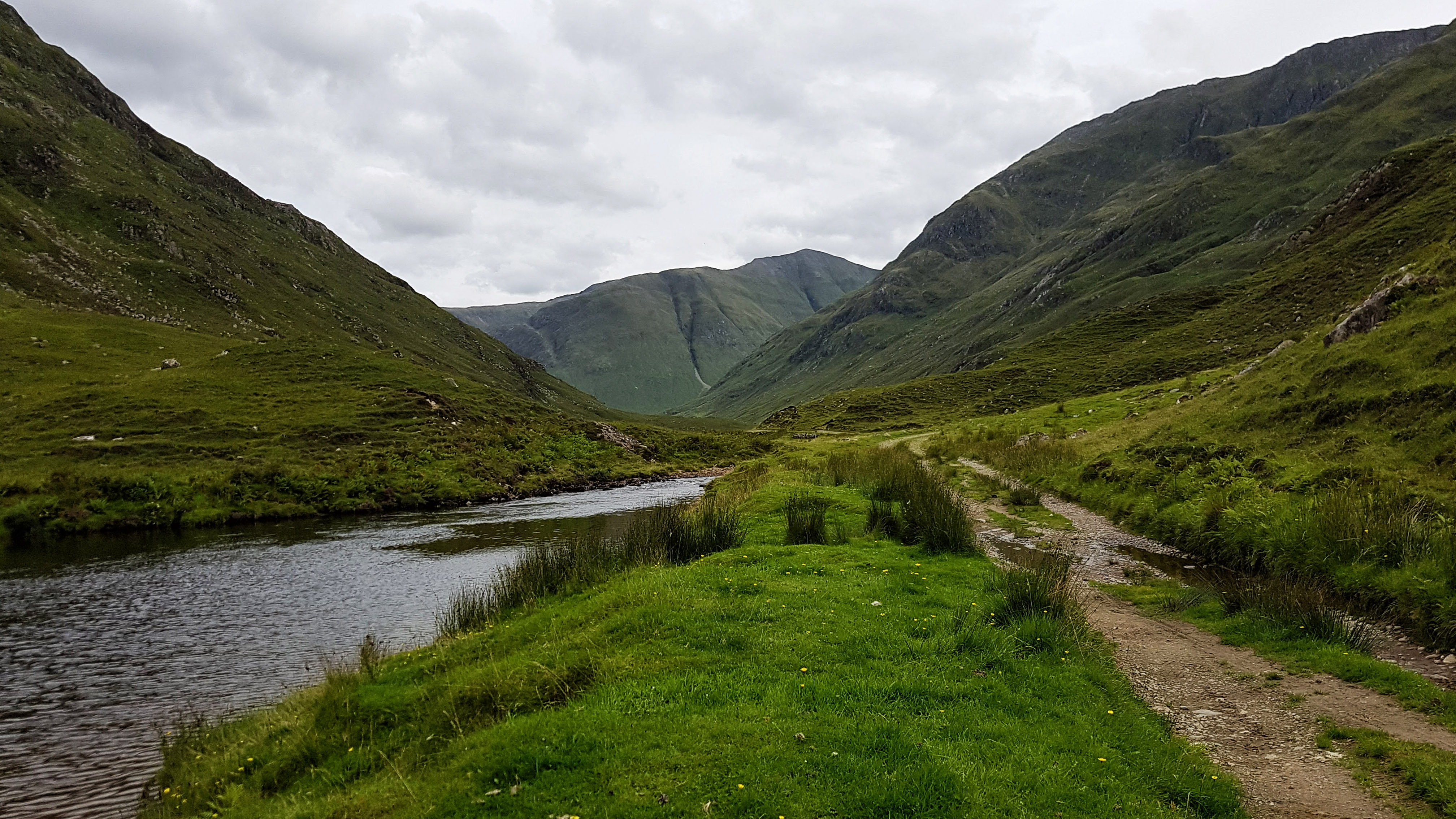
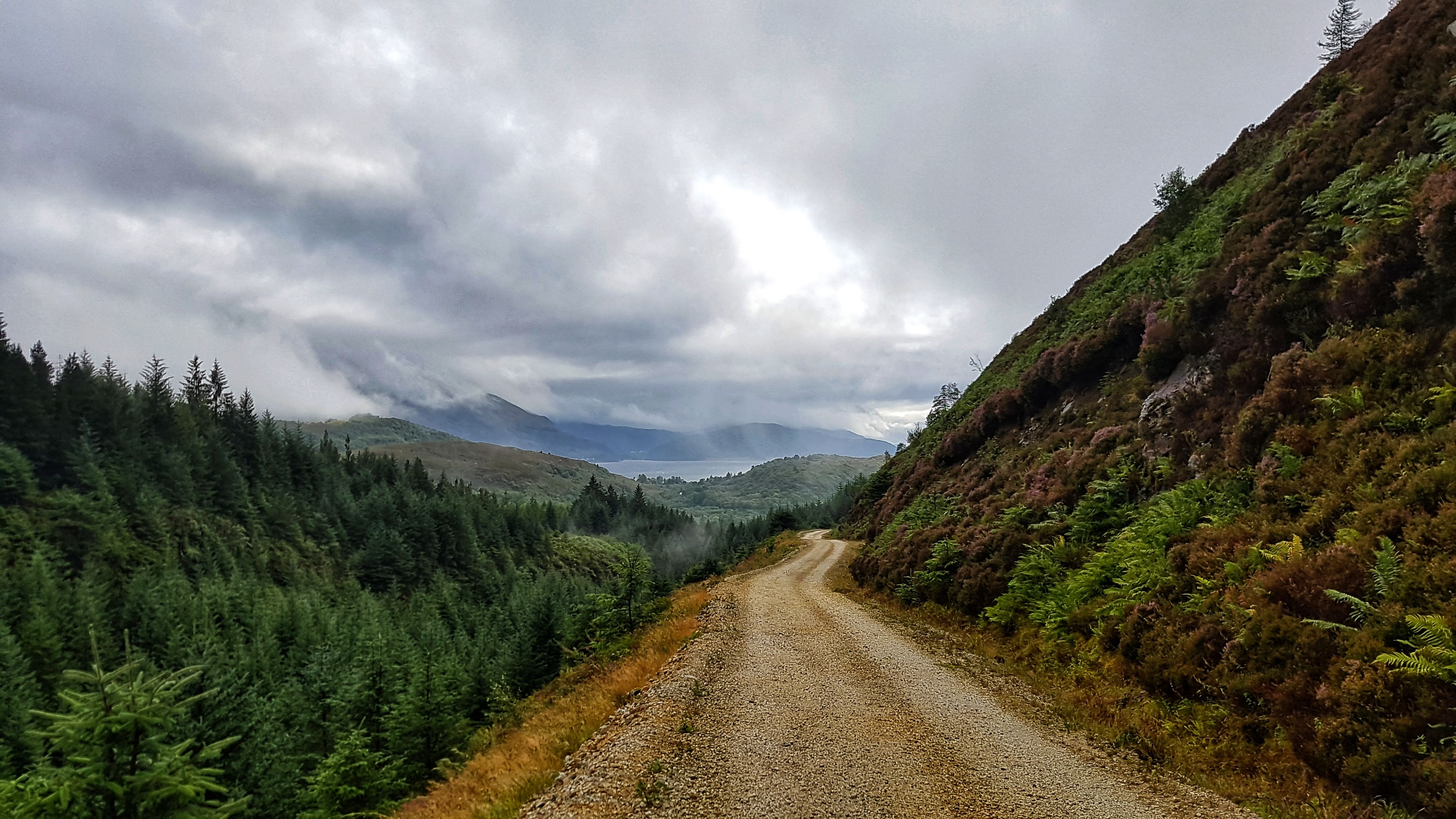
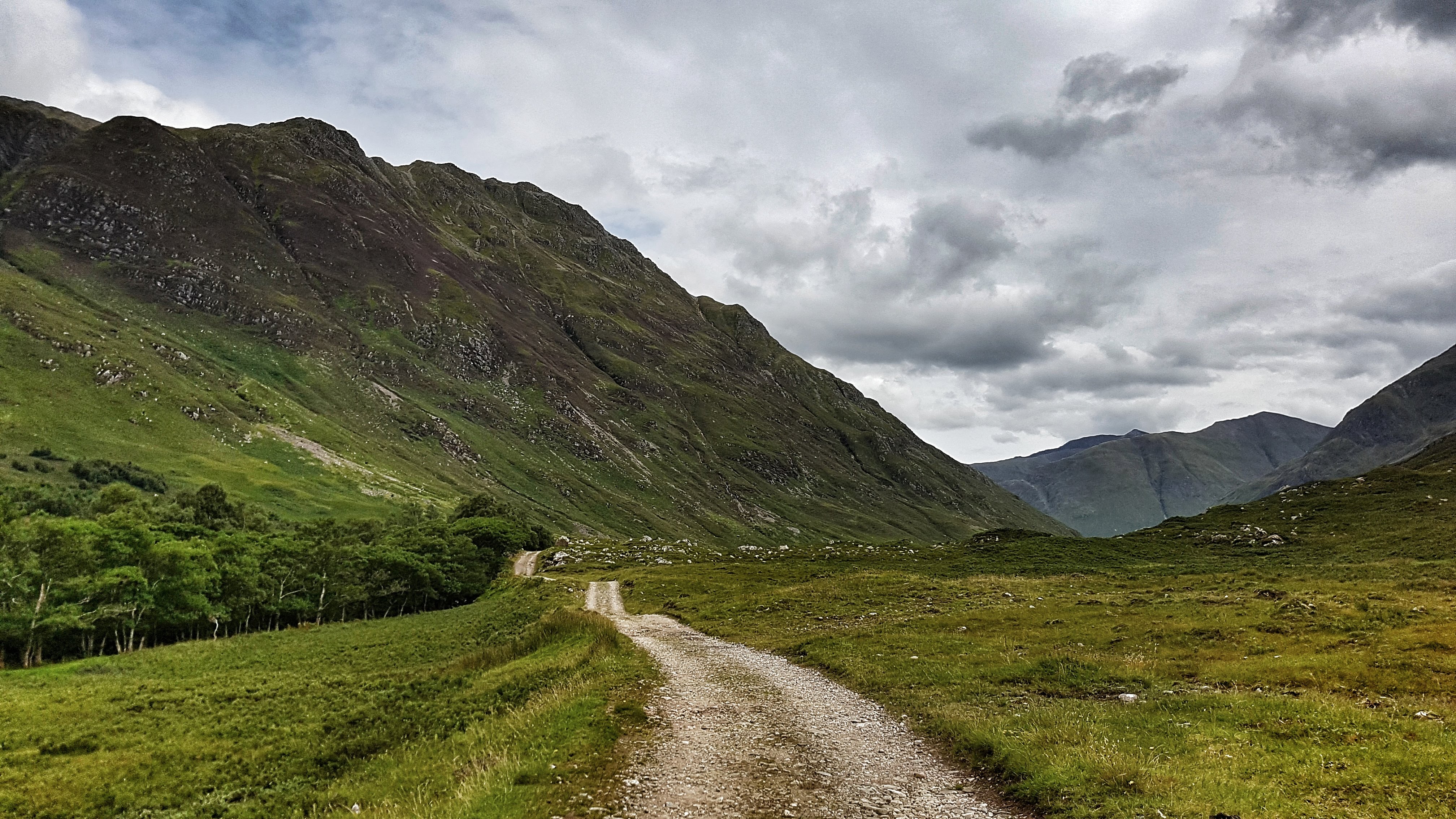
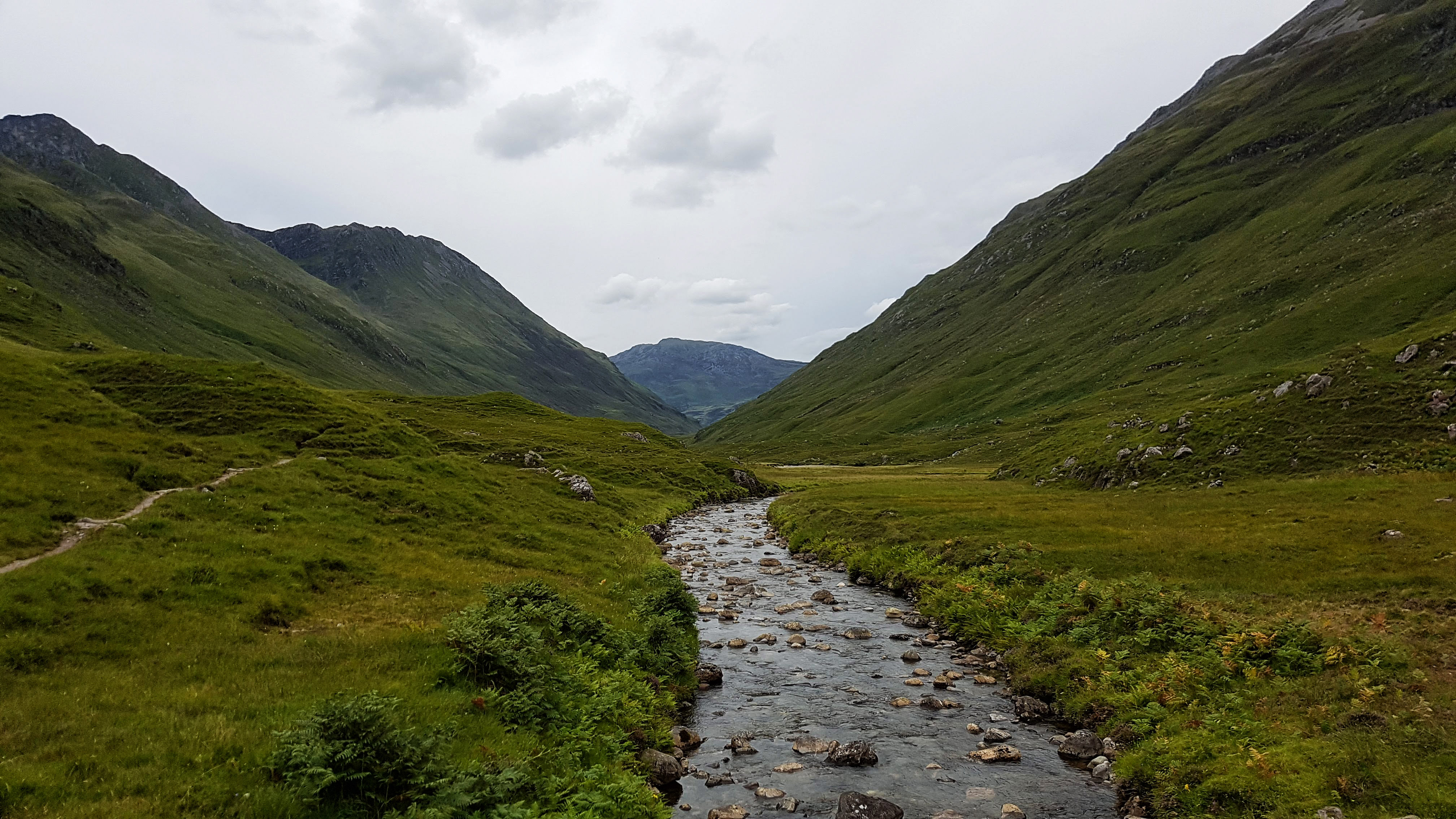
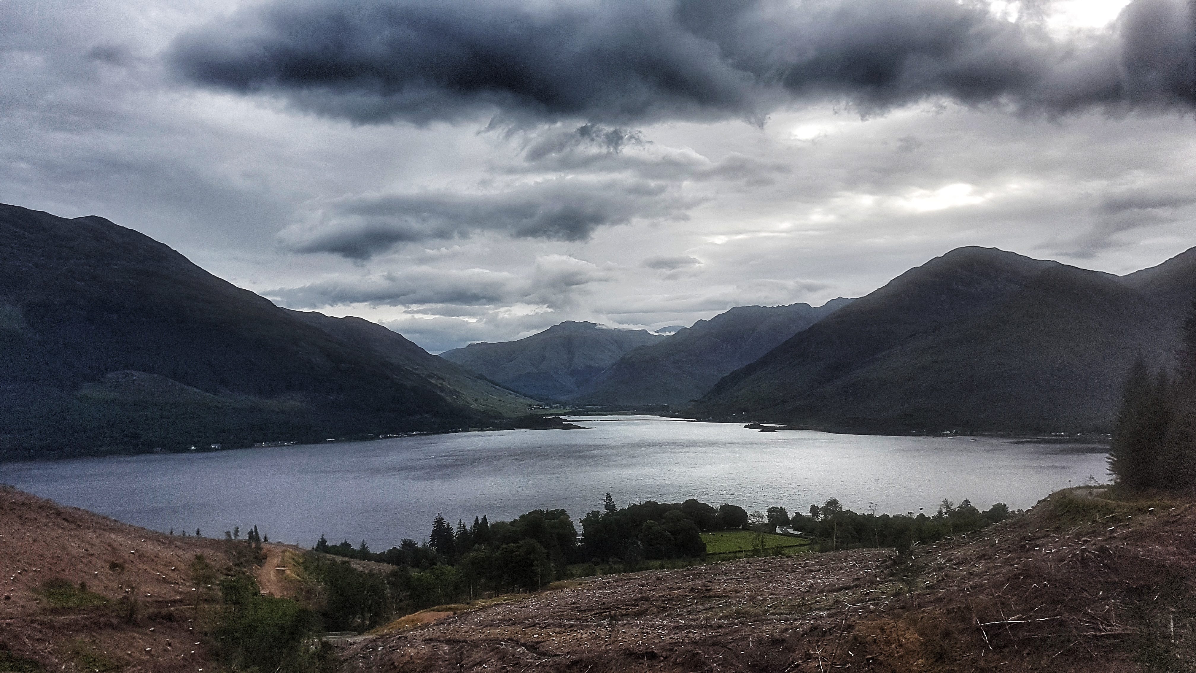
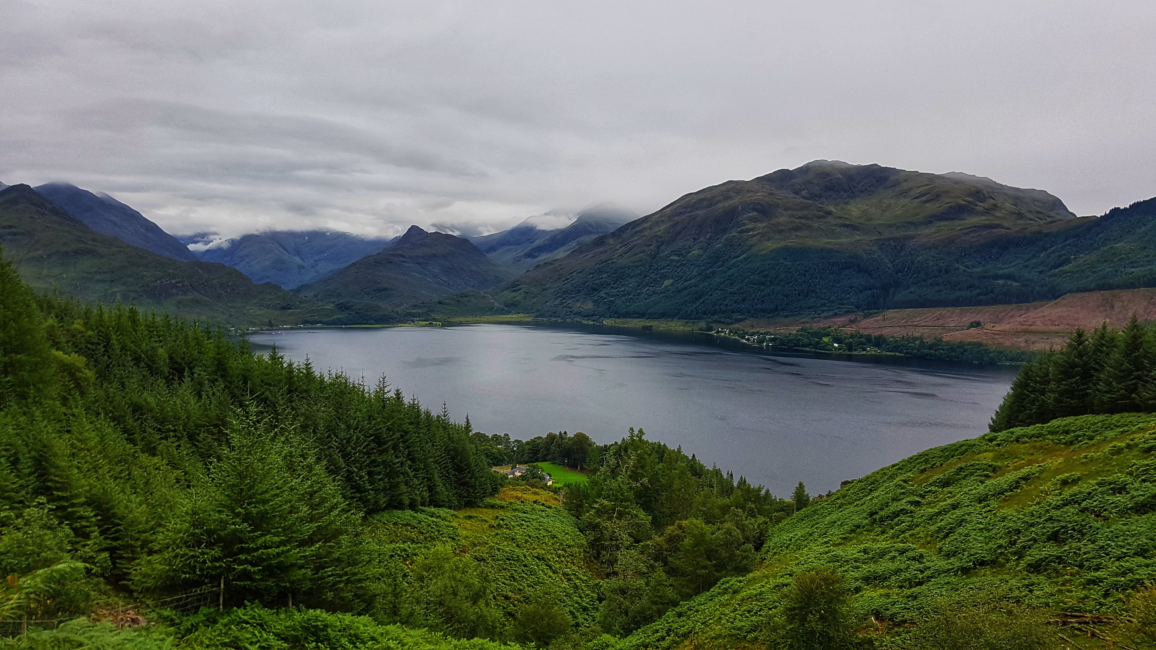
Hugging the River Croe the path offered constantly changing views of the multitude of surrounding hills and mountains knwn as the Five Sisters of Kintail. The run out was a start / stop affair as I spent almost as much time admiring the scenery and taking photos as I did running.

Spectacular views on the path from Morvich (Also not  a Strava picture).

The path was easy to run on at first but as the minutes passed the gravel began to get bigger and more of the path took on the form of small rocks, which were tricky to run on and required a good deal of concentration to avoid trips and potential ankle sprains.

The beautiful trail running from Morvinch – the sheep nearly the only company I found.

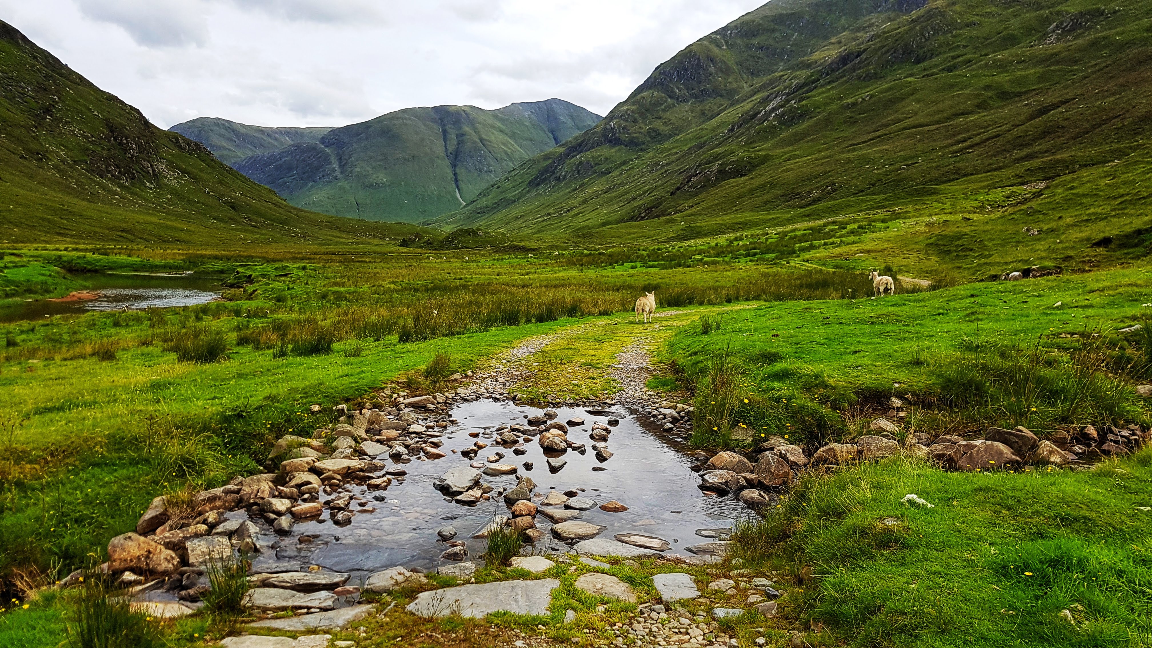
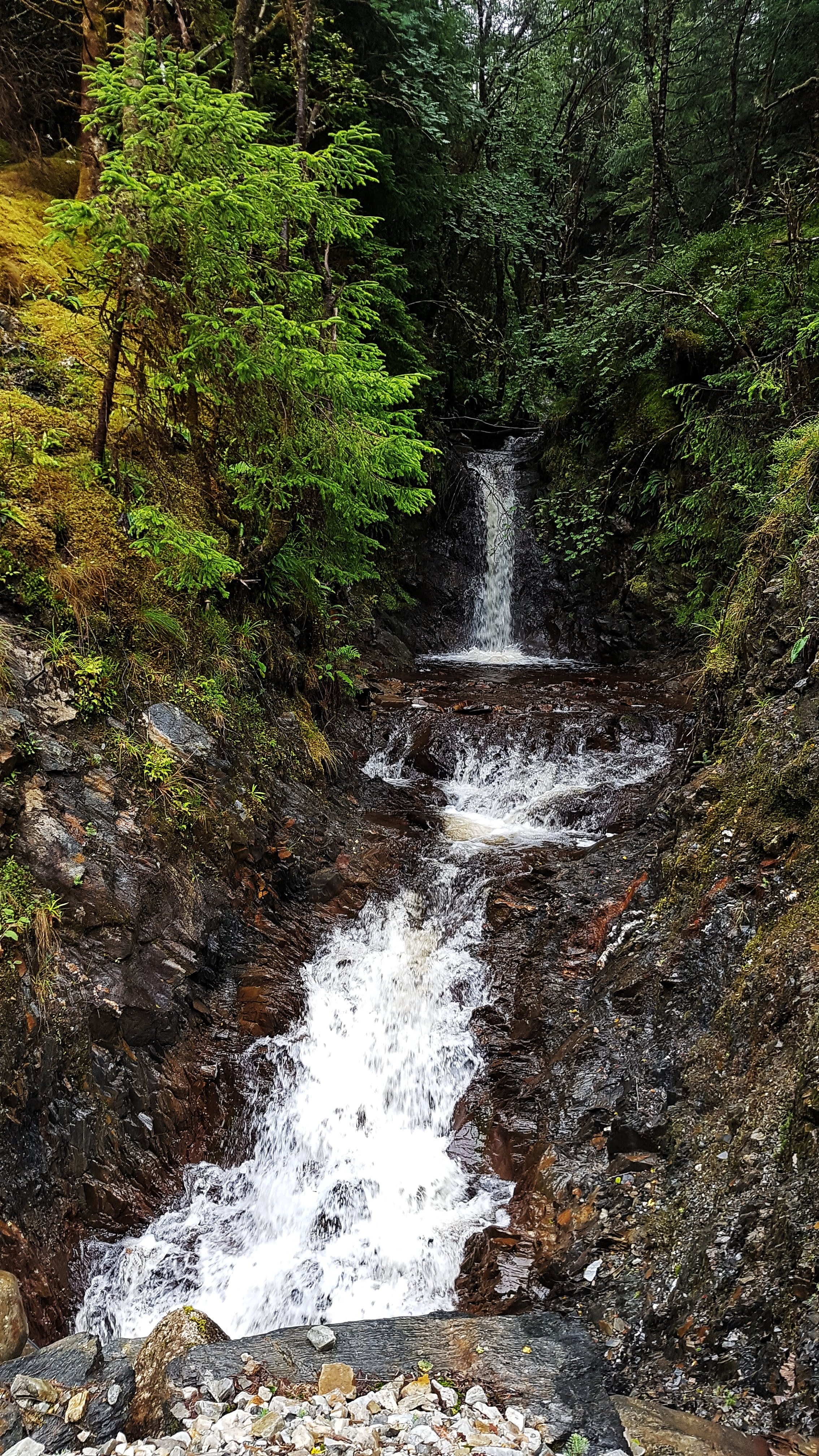
Despite the lack of recent rain there were also quite a few small streams to cross, most of which had rocks handily placed to tip toe across. I imagine in wetter times this run would have been far more challenging. It was at such a stream I encountered pretty much my only company for the day – a flock of sheep. The solitude was further broken a little while later when I passed a small group of young trekkers who looked distinctly weary. I passed them on the way back and rather creepily perhaps (for them) twice more on future runs as they were staying in the same caravan park.

A lone inhabited building in the middle of nowhere.

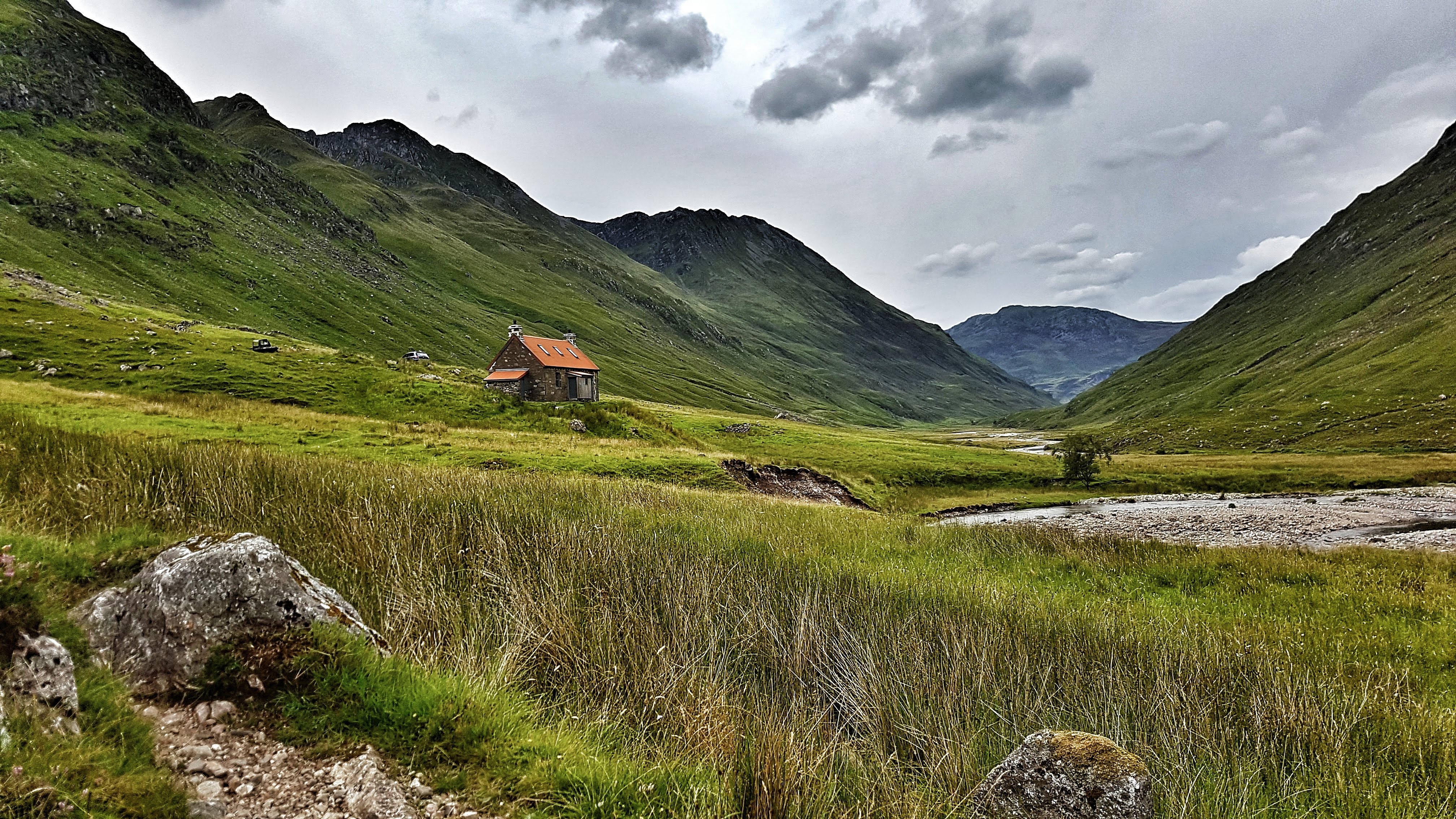
Having run a couple of miles before hitting the path I knew it would be around six miles before I hopefully spotted the lone building. Sure enough I crested a small rise and spotted it in the distance. As I passed it I had to stop and wonder how it must feel to live in a house as secluded as this and what fate befell the owners of a very derelict house next to it.

A derlict lone building on the trail (Another picture that failed to make the Strava cut).

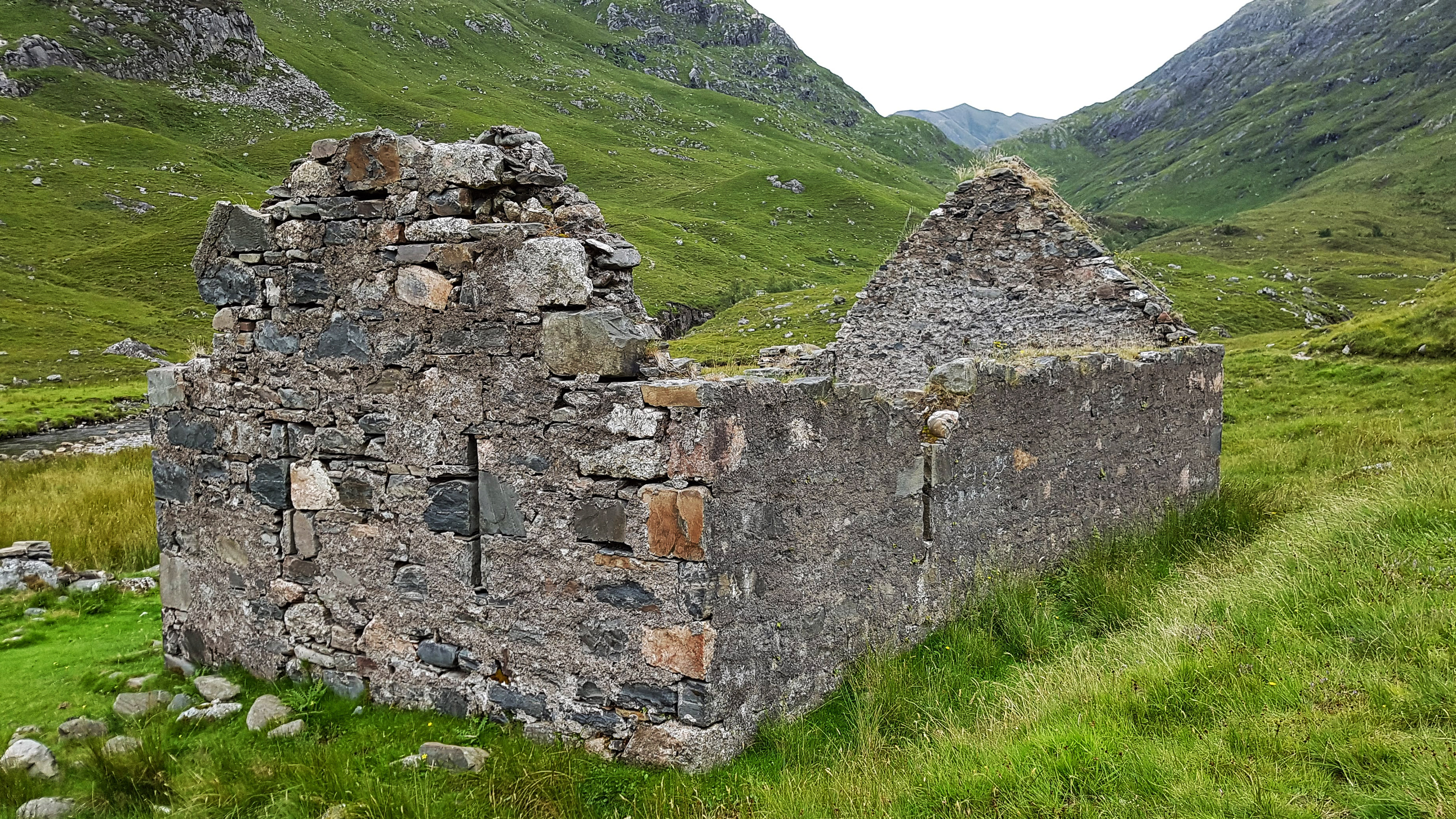
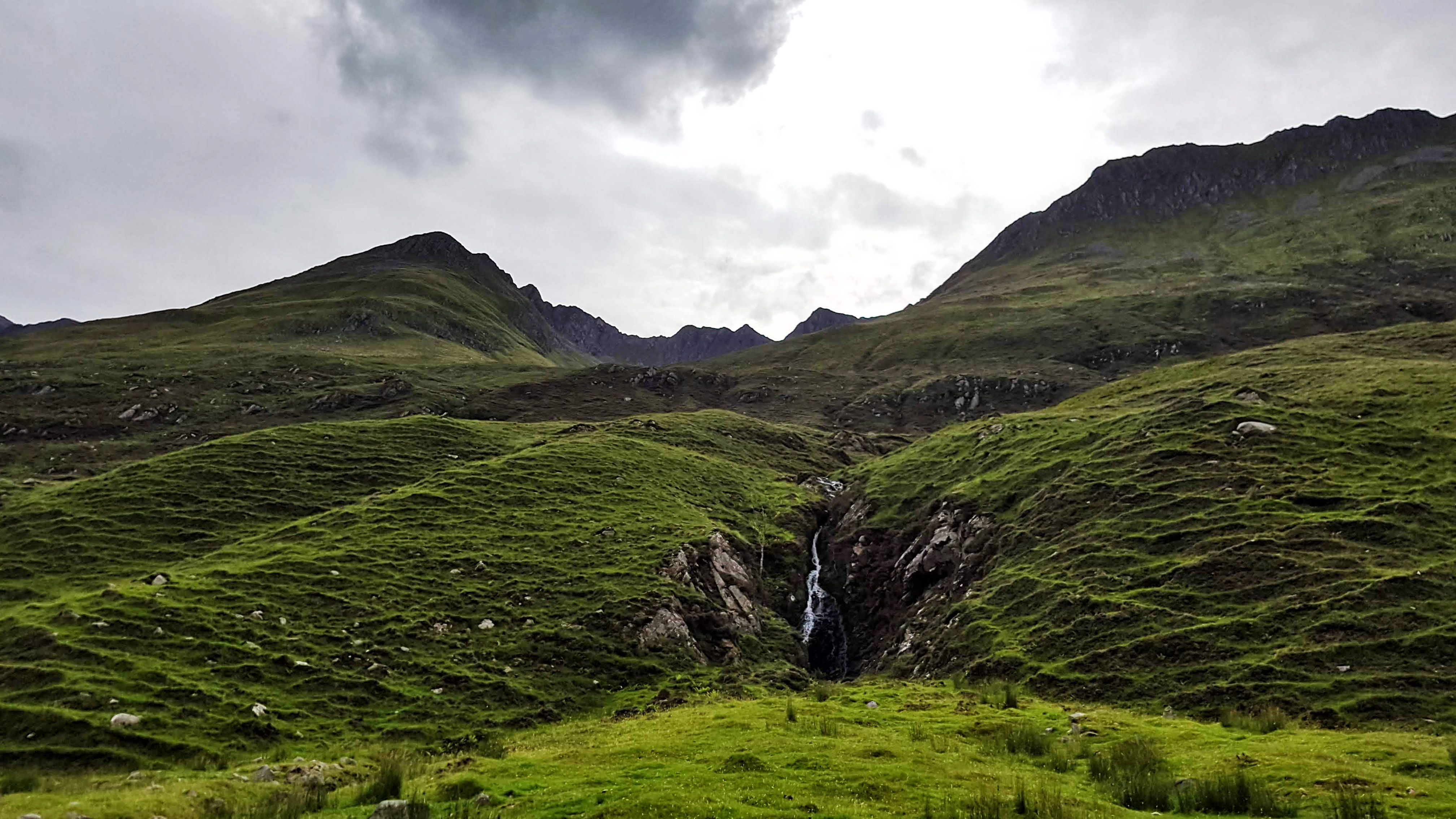
Just a short way past the house was a bridge which I crossed and continued running for just a short way before I sensed it was going to get very technical very quickly as it narrowed and steepened. I turned back around and headed to the bridge – stopping for a minute or two to enjoy the tranquillity.

The view from the bridge (Not on Strava either).

With the sightseeing over it was a case of running the next four and a bit miles back to base. There was no stopping now as I enjoyed the moderately technical nature of the path which was by now really working the muscles in the feet and legs far more used to running on roads and fairly level terrain.

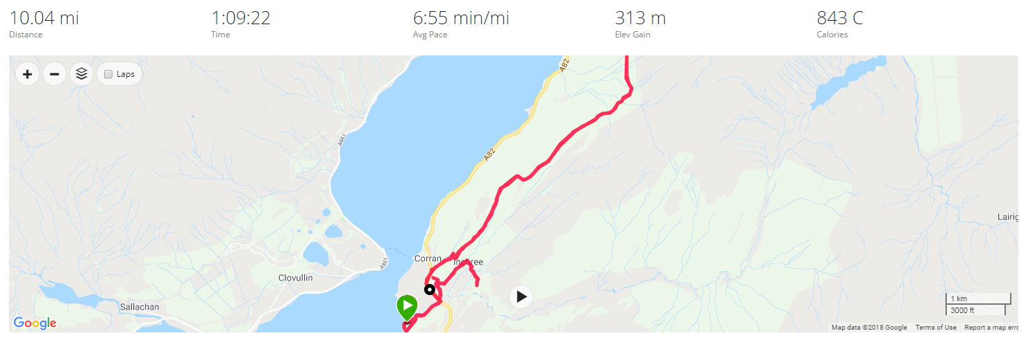
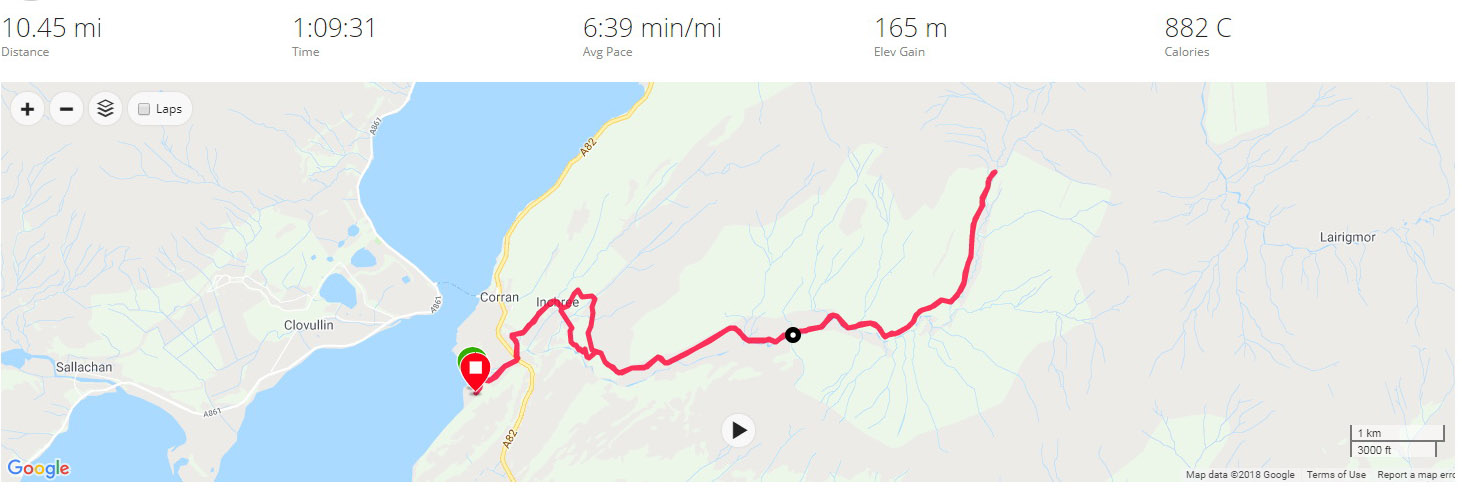
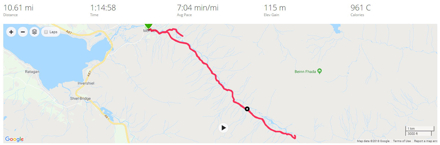
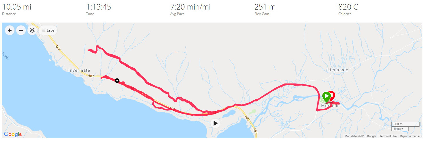
I wasn’t particularly interested in the pace of the run but was pleased to have covered the 10.6 miles in 7:04, especially given how tired I was after the long journey into the Highlands.

Once I’d uploaded my run, I noted there was a Strava segment that looked like it was for a race that takes place in the area. I had no chance of claiming that as I had stopped many times to take pictures. On my return home I did though create a similar segment for the return back to Morvinch which I was pleased to have claimed top spot! This though was not a run about segments but about soaking in the stunning scenery that this part of the world has to offer.

Split Summary
===
1) 1m – 7:35(7:35/m) 121/138bpm 82cal 7.91/9mph
2) 1m – 6:40(6:40/m) 132/146bpm 82cal 9/10.52mph
3) 1m – 6:59(6:59/m) 141/150bpm 97cal 8.59/9.41mph
4) 1m – 7:03(7:03/m) 141/151bpm 95cal 8.51/9.46mph
5) 1m – 7:10(7:10/m) 148/152bpm 106cal 8.38/9.18mph
6) 1m – 7:44(7:44/m) 139/158bpm 87cal 7.77/9.43mph
7) 1m – 7:45(7:45/m) 138/152bpm 87cal 7.74/9.41mph
8) 1m – 6:48(6:48/m) 144/151bpm 89cal 8.83/10.75mph
9) 1m – 6:45(6:45/m) 147/154bpm 93cal 8.9/9.52mph
10) 1m – 6:40(6:40/m) 150/156bpm 96cal 9/9.75mph
11) 0.61m – 3:51(6:15/m) 146/150bpm 47cal 9.59/11.81mph

Best Strava Segment Performance: Back to Morvich – 1st/79

Day 11 – Sunday 12th August 2018 – Mam Ratagan and Back

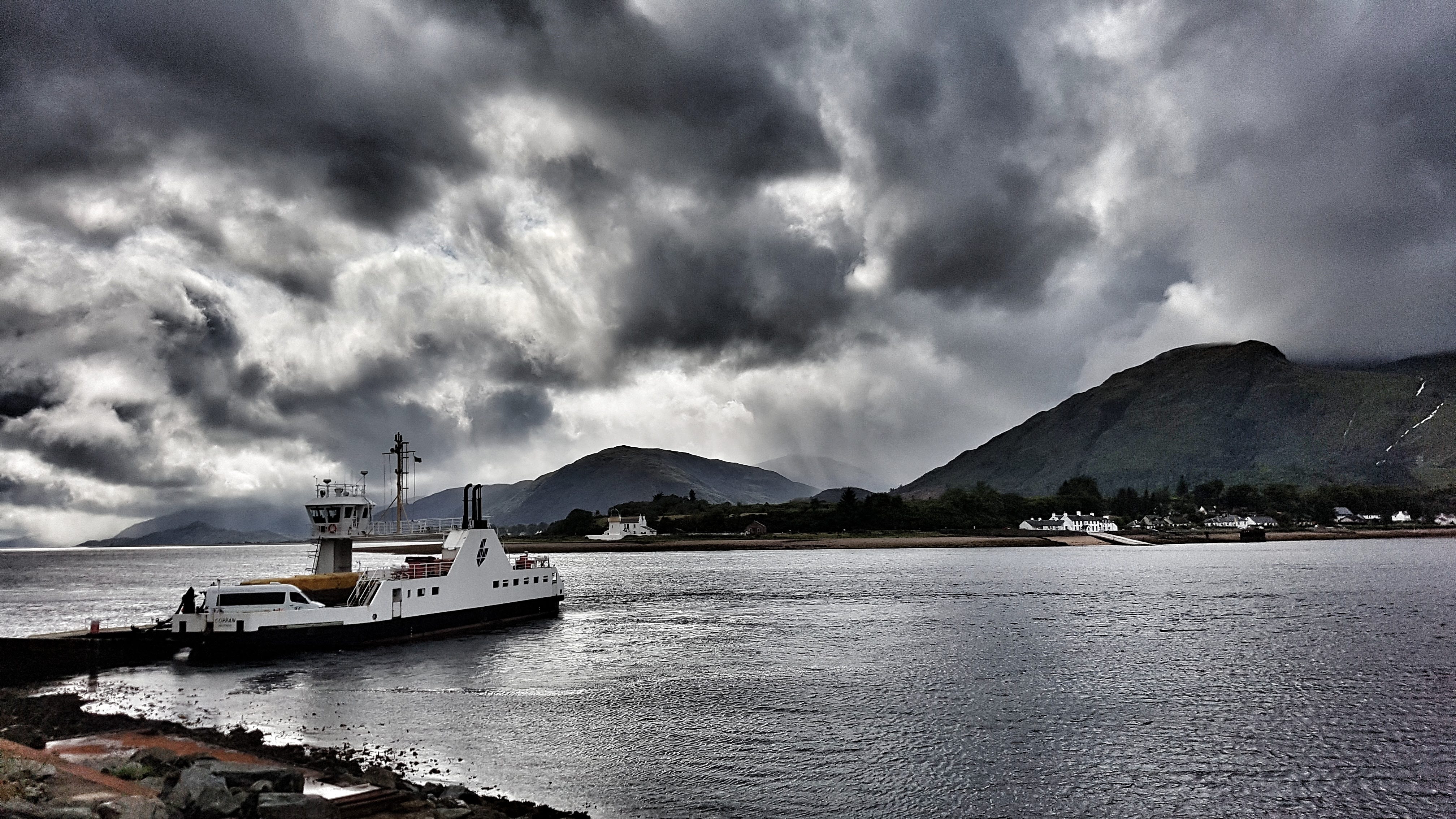
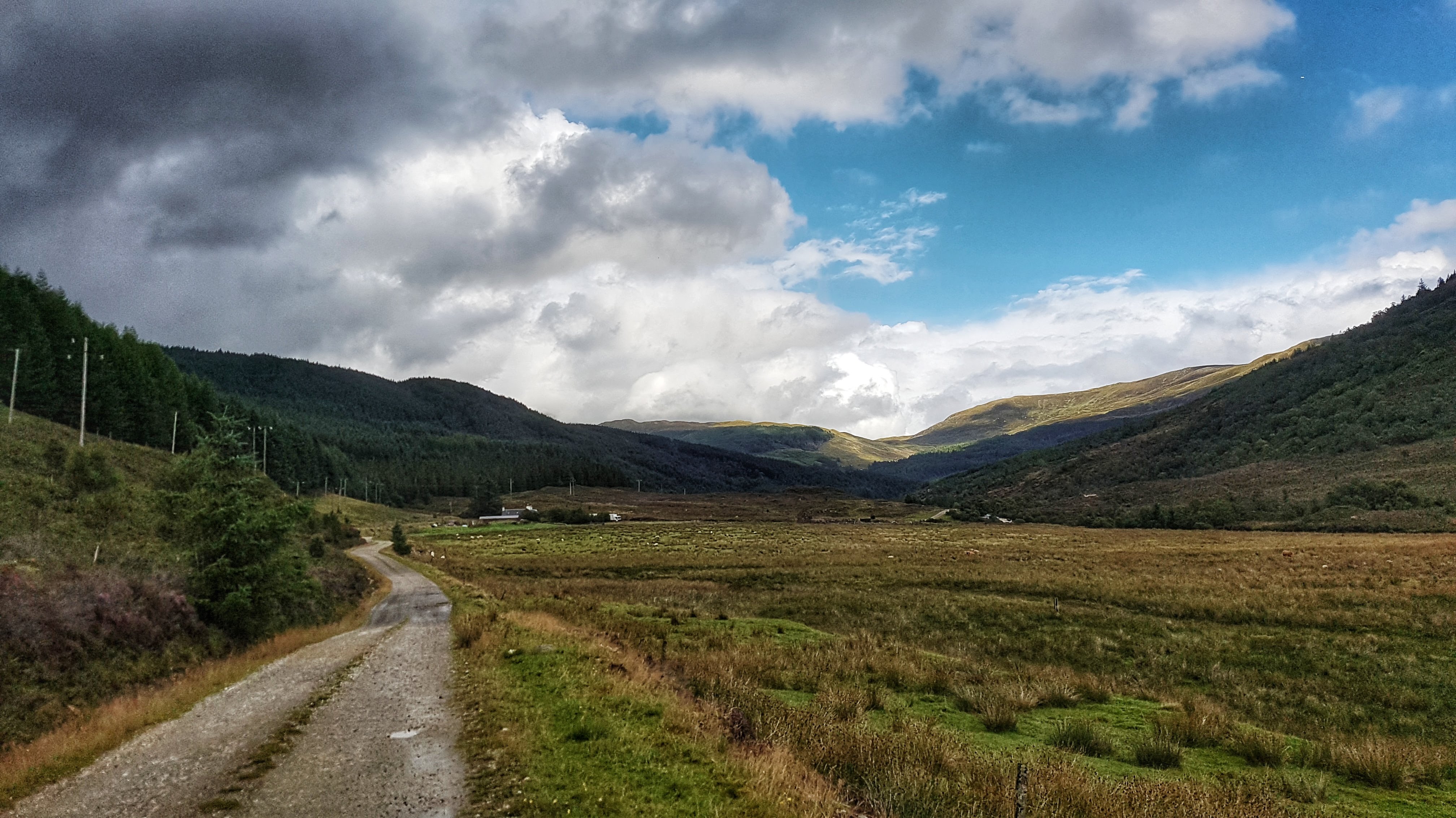
The second run in Morvich and I decided to attempt to take to the only road I could relatively safely tackle in the area. The A87 has a section with a pavement as it heads to Inverinate but much beyond that and it is no place for a runner to be, especially in the month of August with the multitude of caravans and motorhomes flying along the twisting road.

The road I had to play with was the Old Military Road, which runs on the opposite side of Loch Duich and is signposted as a tourist route alternative to the A87 and the Isle of Skye via a ferry. While it was unlikely to be traffic free I was confident that the A87 would take the vast majority of the through traffic and it would be no more risky than many other country roads I have run on.

Heading off at 8:30am the run was immediately compromised by a landslide (which had occurred some time before we had arrived) on the most direct route out of Morvich to the A87. I had no alternative but to take the diversion onto the A87 and over the causeway and bridge that was built to bypass the A87 away from Morvich itself. This added around a mile each way to the run, but thankfully at least there was a pavement to run on.

Loch Duich at Shiel Bridge.

Once over the bridge the pavement left the main road briefly to a quiet footpath before rejoining the A87 at Shiel Bridge. Just as the pavement ran out I could take the right turn over Shiel Bridge and onto the Old Military Road. This road was originally built in the 1750s before being rebuilt in the 1820s taking a route from Fort Augustus to Bernera. Having perused the road on Google Maps I fancied a run up to the Mam Ratagan viewpoint a few miles literally up the road.

My legs were not too bad after the day before – after the customary steady opening mile (7:34) I slipped into a comfortable pace of around 6:50 for miles 2 to 4. I then began the near two mile long climb which only averaged 5% but held some surprises along the way. Part of the Highlands experience has to be running some proper hills, so I was, in a perverse way, looking forward to the challenge.

Loch Duich running up Mam Ratagan.

It began as a drag and then as I worked my way further and further up it began to steepen: 8%, then 10% then, as it approached where I assumed was the top it was signposted as 18% average but in places felt much steeper – not quite the 30% the Strava segment suggests, but probably short sections were around 20-25%.

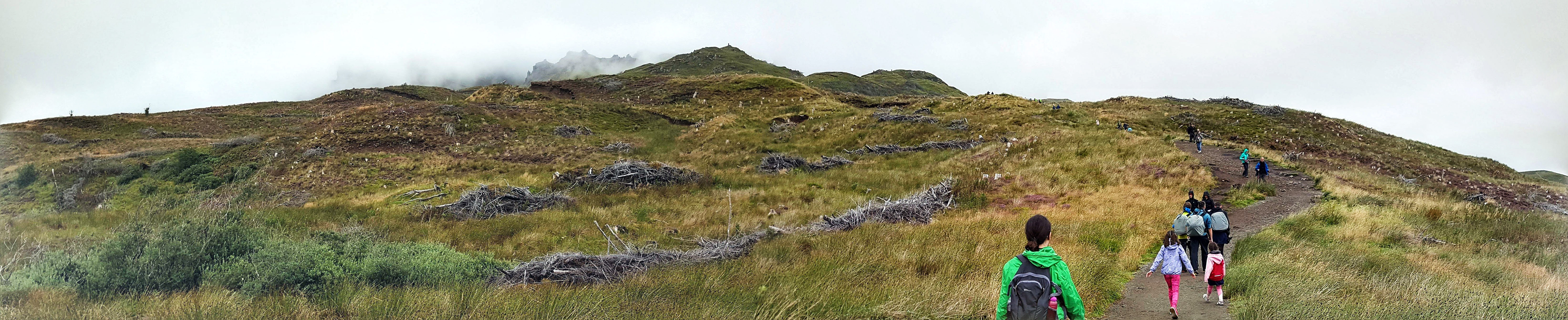
Slowly making my way up I stopped briefly to take a photo before taking on the final onslaught via a set of steep hairpin bends which made my running feel like a crawl to the extent where walking felt like it could have been a quicker option.

View from Mam Ratagan.

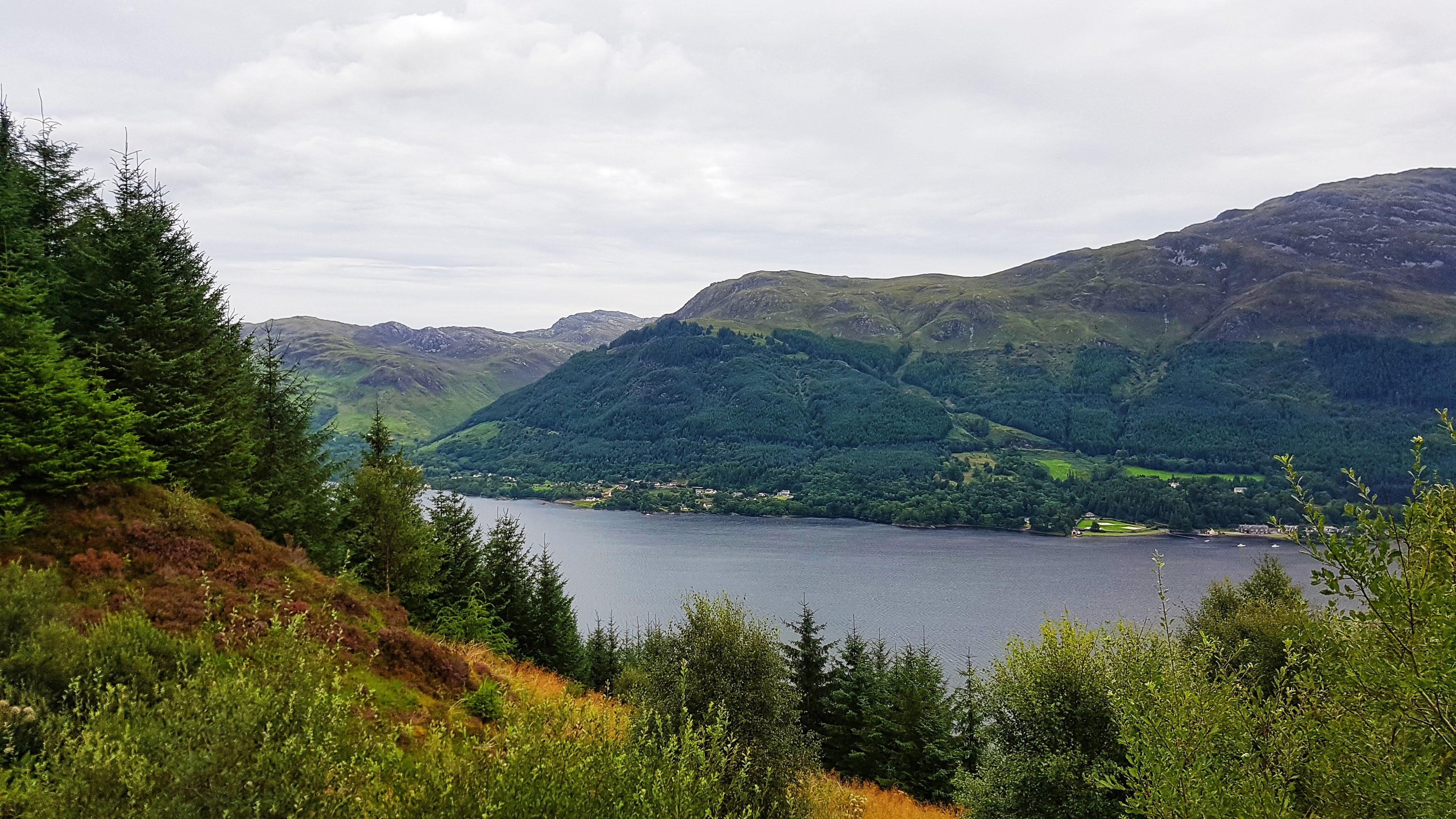
With one final effort I finally reached the Mam Ratagan viewpoint. I stopped briefly to take in the scenery and to take a photo, but as I was sharing the experience with a young couple who had clearly slept the night there in their car (A common occurrence in Scotland where laws on where you can stay overnight are different from the rest of the UK) were thankfully doing nothing more than brushing their teeth, I kept the visit short. While the view there was good, the abundance of growing trees at this point, made the vista slightly lower down the hill, in my opinion, slightly superior.

A little later on in the day, it was a surprise when I uploaded my run to the world that I had claimed both the Old Military Road Climb segments on Strava despite at least one stop to take photos. That said, the road is not exactly over frequented by runners, based on the single digit numbers of those who have uploaded to Strava and covered the segment. It may though be more popular with cyclists as it features in the Scotland edition of the seminal Britain’s Greatest Cycling Climbs. I only discovered this by chance from a club mate who noted my effort on Strava and wondered if I’d deliberately targeted it. I was a bit disappointed to find out that I never quite made it to the top of the climb as described in the book. It’s a long way to go back to finish the job!

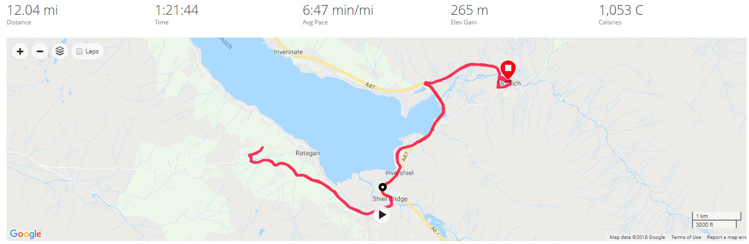
The out section of the run covered with just under six miles on the Garmin I knew it was going to be run closer to 12 miles than the customary 10. As I plunged down the steepest section of the climb I had some severe pains in the quads which normally precedes a bout of debilitating cramp. I tried my best to relax and not tense the legs and was relieved when the gradient reduced a little and the pains subsided, not to the point of them disappearing, but enough for it to not affect the remainder of the run.

Having taken a hit with the uphill (a 7:05 and a 7:59 mile, although Strava GAP has them both as sub six minute miles) the average pace for the run recovered as I continued the 2.4 mile downhill run back to Shiel Bridge, running 5:58, 6:15, and 6:28 for miles 7-9. Back on the A87 I decided that it was probably best to continuing pushing rather than easing up as far as the quads were concerned, so continued with 6:37, 6:30 and 6:29 miles, not stopping at any point of the run, to end the 12 miles in 1:21:43 at an average of 6:47. This was pretty pleasing considering the severity of the climb I’d run as I passed the halfway mark in the Tour of Britain.

Split Summary
===
1) 1m – 7:35(7:35/m) 124/138bpm 88cal 7.91/8.97mph
2) 1m – 6:55(6:55/m) 132/140bpm 89cal 8.67/9.18mph
3) 1m – 6:46(6:46/m) 135/143bpm 86cal 8.87/9.75mph
4) 1m – 6:48(6:48/m) 138/147bpm 85cal 8.83/10.98mph
5) 1m – 7:05(7:05/m) 153/165bpm 108cal 8.47/9.35mph
6) 1m – 8:00(8:00/m) 160/169bpm 122cal 7.5/9.85mph
7) 1m – 5:58(5:58/m) 133/138bpm 50cal 10.06/11mph
8) 1m – 6:15(6:15/m) 139/148bpm 72cal 9.59/10.54mph
9) 1m – 6:28(6:28/m) 146/150bpm 86cal 9.29/9.87mph
10) 1m – 6:37(6:37/m) 149/152bpm 92cal 9.06/9.43mph
11) 1m – 6:30(6:30/m) 151/155bpm 91cal 9.22/10.27mph
12) 1m – 6:29(6:29/m) 148/156bpm 81cal 9.25/9.83mph
13) 0.04m – 17(7:22/m) 146/146bpm 3cal 8.15/8.83mph

Best Strava Segment Performance:s Old Military Road Climb – 1st/12; Old Military Road Climb – 1st/7; Down Old Military Road to Shiel Bridge – 1st/2; Keeping Safe on the A87 – 1st/72; From the A87 to Morvich – 1st/28

Day 12 – Monday 13th August 2018 – Loch Duich – high and low

Having tackled the only obvious footpath on the Saturday and the only real safe road on the Sunday, I must admit I was wondering where I was going to run for the third and final run in Morvich. It was only when I was driving back along the A87 near Inverinate with the family from a trip to Kyle of Lochalsh and a rainy Plockton, that I spotted on the side of the road a sign for a footpath into woodland. This looked as though it could be just what I needed!

A long journey to the Isle of Skye was planned for later in the day so it was out of the caravan fairly early at 8 am for the Monday morning run. The first mile was fairly slow and tortuous while the legs struggled to wake up on the road out of Morvich. I wasn’t long on the A87 when I spotted a different path to the woodland than the one I’d seen the day before, and grabbed the opportunity to explore without hesitation.

A woodland path heading towards Inverinate.

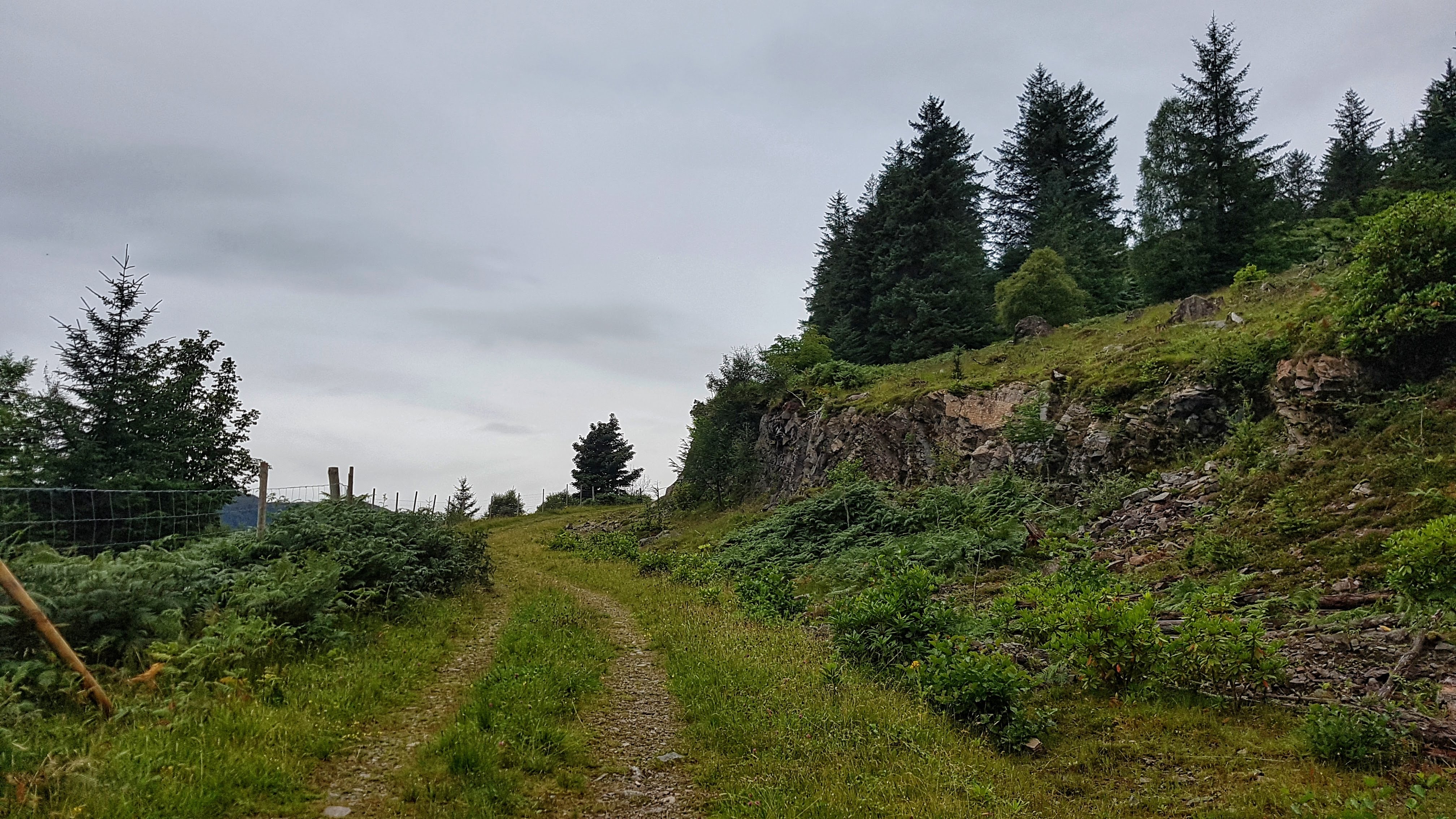
I soon began heading upwards: rocks, trees, and the occasional stream to the right of me, trees, trees, and more trees to the left. It was quite hard work as I climbed a not especially steep gradient, the legs still a little unwilling to activate. Mile three was a pedestrian 9:01, although Strava GAP reckons it was worth a 6:45 once the elevation is taken into account.

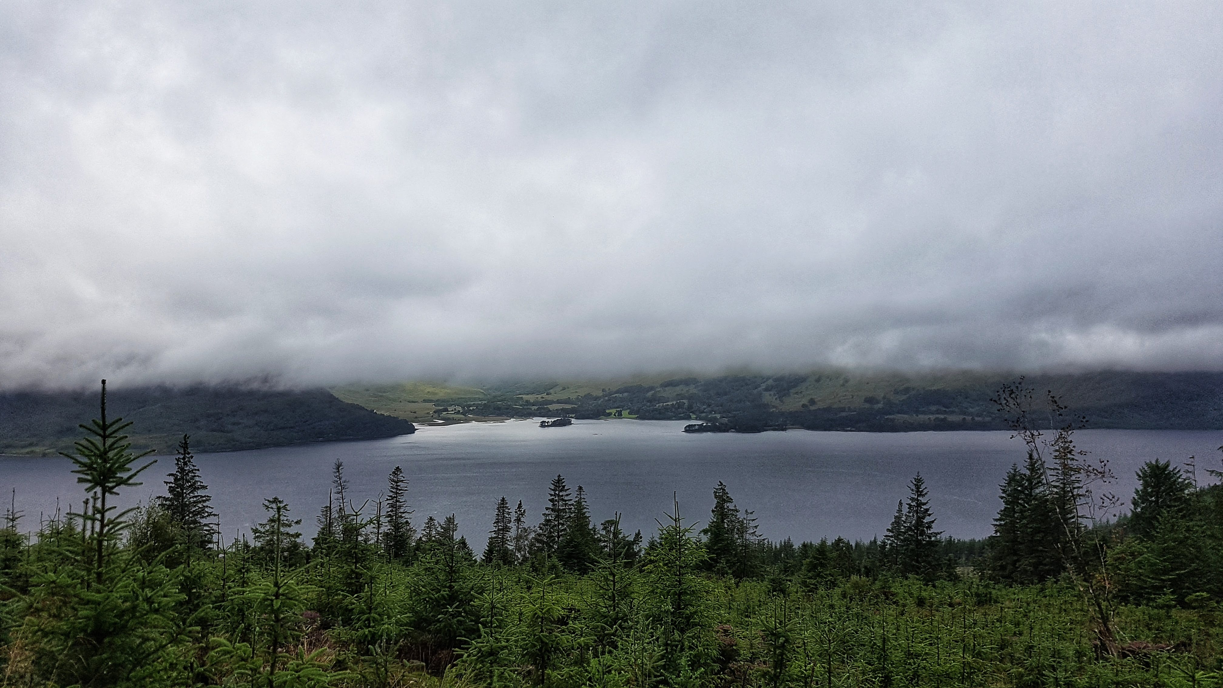
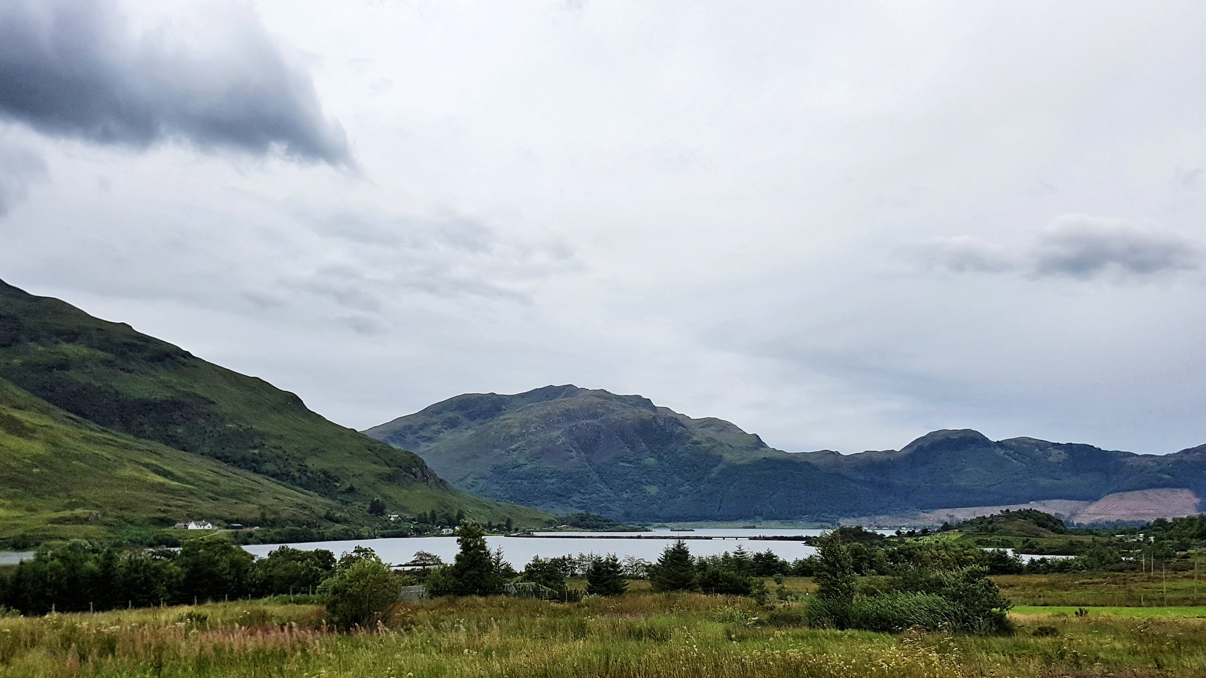
After a mile and a half of climbing the hill levelled off and there was quite a rock formation to the right of me and quite a remarkable view to the left of me, with a splendid vista of Loch Duich around 200 feet below me.  I stopped to reel off some photos and take stock of the view before carrying on along the track. Alas as the track became less pronounced and the abundance of grass more apparent I feared the end was nigh and indeed it was that the path came to an abrupt end.

Loch Duich – high.

There was little else to do but turn around and head back from where I came – this time quicker thanks to gravity but not especially fast – this was not a day where any world records would be set. Two thirds of the way down I spotted what looked like an alternate route but reckoned it would be prudent to stay on the path I knew. This took me back on the A87, but with only just over five miles covered, I knew I had to do some more exploring to make up the distance.

So I headed up the A87 back towards Inverinate, knowing there was a pavement beside it for a good deal of the way. I passed some houses and a small primary school; once the houses ceased a fairly long uphill drag commenced. I spotted the gate to the woodland path I’d spotted in the car the day before and tried to get in. However I couldn’t get the gate to open and the sight of an unleashed dog staring at me with angry eyes in the distance made me think better of this route and went back to the main road.

Loch Duich – low.

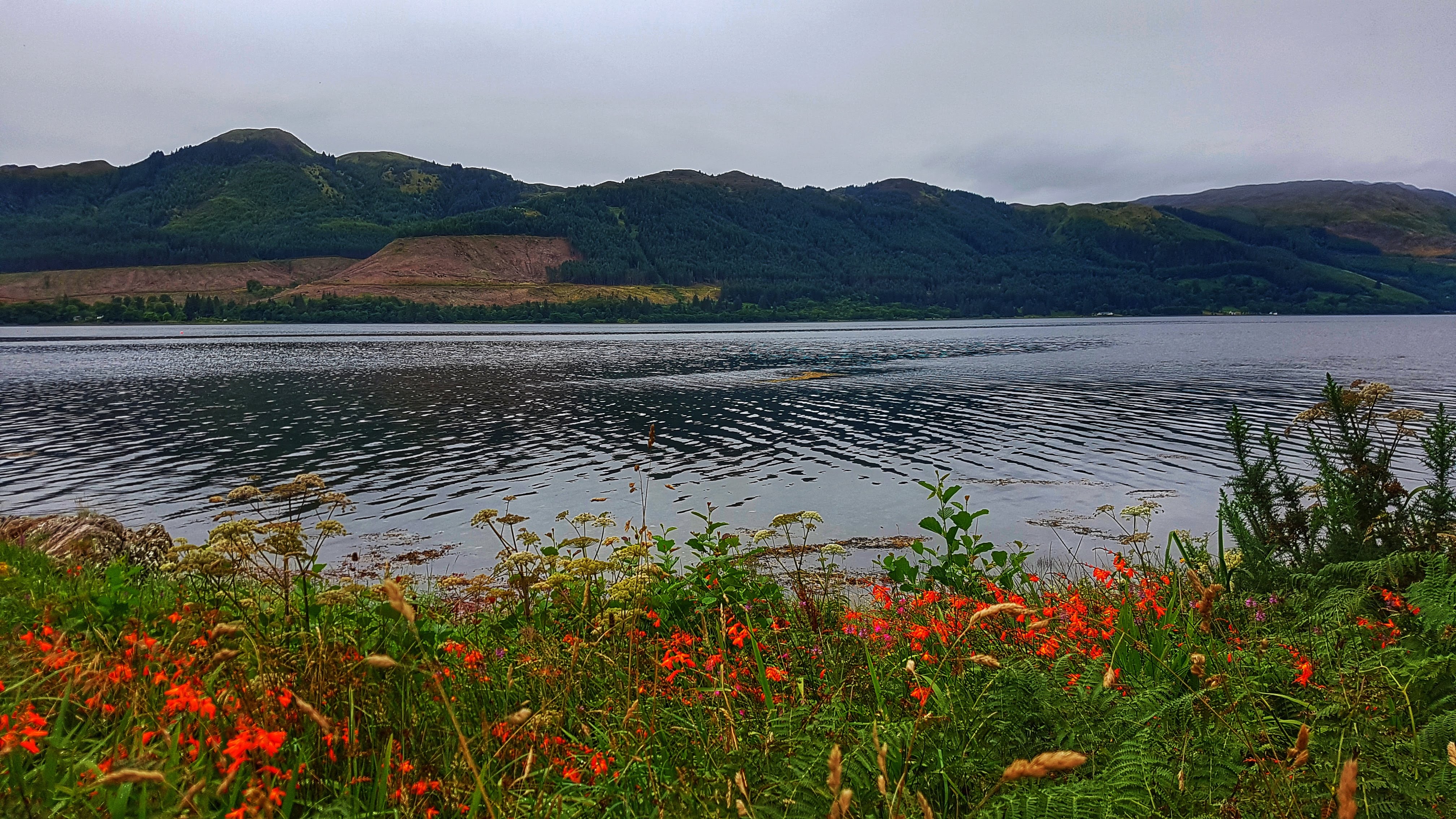
After a mile and a half or so I reckoned I could turn around and head back and clock 10 miles by the time I reached the Caravan Park. This I did via a small diversion from the A87 down a small footpath and a quiet road where the select group of residents could enjoy a most tranquil view of Loch Duich each and every morning. Buoyed on by quite a long gentle down hill run I was able to maintain a good steady pace for the remaining couple of miles in 6:35 and 6:25 respectably. This couldn’t prevent however, at 7:20 per mile, this run being the fourth slowest of the Tour. But what it lacked in pace it made up with one of the most memorable Surprise Views of the holiday.

Split Summary
===
1) 1m – 8:03(8:03/m) 122/134bpm 90cal 7.45/8.33mph
2) 1m – 8:04(8:04/m) 129/143bpm 96cal 7.44/9.2mph
3) 1m – 9:01(9:01/m) 139/151bpm 117cal 6.65/7.58mph
4) 1m – 7:31(7:31/m) 124/146bpm 65cal 7.98/8.87mph
5) 1m – 6:49(6:49/m) 121/136bpm 52cal 8.8/9.27mph
6) 1m – 6:57(6:57/m) 127/140bpm 66cal 8.64/9.5mph
7) 1m – 7:10(7:10/m) 137/149bpm 85cal 8.36/10.6mph
8) 1m – 6:46(6:46/m) 132/146bpm 67cal 8.88/9.91mph
9) 1m – 6:35(6:35/m) 142/147bpm 88cal 9.1/9.73mph
10) 1m – 6:25(6:25/m) 146/152bpm 89cal 9.36/10.18mph
11) 0.05m – 23(7:04/m) 143/145bpm 5cal 8.48/9.31mph

Best Strava Segment Performance: From the A87 to Morvich – 1st/28

Leg Four Summary

Distance Run: 32.7 miles. Average Pace: 7:03 per mile. Accumulated Time: 3:50:27. Average HR: 138; Total Ascent: 1174 meters.

The ‘2018 Tour of Britain’ Leg Five – Bunree (Onich)


Bunree Caravan Club Site – probably the best backdrop we’ve stayed at (And the poorest weather!)

Bunree lies just north of Onich on the eastern shore of Loch Linhe and consists of little more than a few houses and a Caravan Site. With the A82 nearby however it is only a few miles from Glencoe and Fort William – which is the main town in this part of the Scottish Highlands and just a few miles from Ben Nevis.

Glen Nevis before the rain again came down!

While the views are undoubtedly spectacular, poor weather for the majority of out three day stay meant our tourist exploits were limited to an afternoon in Fort William, a very wet walk in Glen Nevis, and an enjoyable short walk up to Inchree Falls – just a mile or so away from where we were staying – where we were also able to spot some red squirrels!

Day 13 – Tuesday 14th August 2018 – Lost the woodland trail so played it safe on the A82…

Not long after arriving at the spectacular Bunree Caravan Site I was reading the welcome brochure over lunch and it soon became clear that the place to head to for my first run was the nearby Glen Righ Forest, which promised miles of paths and tracks – ideal for walking and mountain biking. They didn’t specify running per se but I knew that this could be a runner’s playground!

It was a wet and wild afternoon in the Highlands so I was a little delayed heading out as the caravan’s awning was doing it’s best impression of being a sail as we struggled to attach it to the caravan and peg it down before it blew away.  Finally at 3:40 pm I was on my way – thankfully the rain had stopped and the wind began to die down, the sun even threatened to make an appearance!

Half a mile of single track road later and I was on the busy A82, but it was just a case of crossing it and heading onto a small road that took me through the small village of Inchree and on to the Glen Righ Forest car park. There was an information board which offered up two circular walks – one was to the Inchree Falls, the other called Wades Road Walk, named after the Military Road.

I wanted to save the waterfalls experience as a family one so I opted for the Wades Road Walk, which was advertised as 3.8 km long. I set off along a trail which was narrow but very well maintained and not that technical as it made it’s way rapidly deep into the heart of the forest.

The photo doesn’t do justice to the colours in this forest (and the severity of the climb!)

The trail may not have been technical, but boy was it steep! My first mile, that took me to the car park, was a 7:34, my second mile 9:01, but Strava GAP rates it as a 6:12, having climbed 440 feet in just over 3/4s mile at an average of 9%, with a savage section of just 0.13 mile which averages 17% on the Strava Segment. I’m not sure the steepest bit of it is 72.7% as Strava claims, but I reckon it was around 33% for around 20 seconds of running. Given that I did this section at 10:47 per mile pace, yet sit third in the Strava segment gives an idea of its severity. The amusingly spoonerised segment for the entire climb Hairway to Steven has me second, a minute off the leader, which would have been less had I not stopped to take the photo above!

Arguably the most scenic half mile of running on my Tour in Glen Righ Forest.

Just as I felt like my legs would give up completely, thankfully the climb fizzled out as I presumably joined the Old Military Road. Following the coloured post I took a left turn or two and began to drop back down the hill I had just risen. It was probably a combination of the adrenaline still coursing through me after the hill as I began to hurtle downhill, the sun just attempting to break through after four days of thick cloud cover and the stunning scenery, with views of the forest, the mountains and the Loch below, but this half mile of running (as shown in the photo above) was perhaps the most enjoyable and scenic of the entire Tour.

Alas the views were not to last forever as the descent got steeper and steeper and dropped back into the forest, round some pretty tight alpine style hairpin bends. I think I missed the turning back to the car park for I continued to drop, quite quickly (a 6:22 third mile) past some holiday lodges and suddenly onto the A82. I had to rely on Google Maps to advise me that I had popped out around a third of a mile north from where I had last seen the popular A road.

Luckily for me, although the overwhelming majority of the A82 has no pavement and is wholly unsuitable for running on, this section did in the form of a shared cycle path. Even more fortunate was the presence of an information board just a little way along the road which explained that this cycle path ran from North Ballachulish to Fort William, using the Corran Ferry and the continuation of the path on the A861 to offer cyclists especially an alternative route to Fort William, avoiding the busy A82.

The Corran Ferry – one of the few remaining ferry services in the Highlands – taking passengers from the A82 to the A861.

With less than four miles covered I knew that I would have to do plenty of exploring to make up the ten miles. I had wanted to spend longer on the forest tracks, but didn’t really fancy another long climb up. Instead I first turned right onto the A82 and headed down to the Corran Ferry crossing, which had a boat just about to depart. Free to foot passengers, I briefly considered taking the short journey across the water but, thought the better of it given that my stomach was giving a few distress signals.

I decided I would instead head back initially to the caravan site to use the toilet facilities before using the cycle path on the A82 towards North Ballachulish to make up the distance. Relieved of stomach cramps I was soon back on the main A82, enjoying a cycle path that was, at that time, used by no-one other than myself.

There was around a mile of running to take me from Bunree to the more populated village of Onich, which sits mostly on the A82 and features a large number of B&Bs, which offer splendid views of, and easy access to the shores of Loch Linhee, which when I dived briefly off the road to take a photo, felt and smelled far more like a sea beach than the side of a lake.

I ran along a bit further, the cycle path looking a lot more like a pavement and barely suitable as a means of taking bikes along. I got to within 3/4s mile or so of Ballachulish Bridge – fortunately for me as someone who really does not like crossing bridges, it was time to turn around and head back to keep the run at 10 miles. The pace had picked up by itself almost without effort, the final three miles 6:21, 6:22, and 6:11 as I enjoyed the relatively flat terrain and good surface underneath me.

All that was required once returning to the Caravan Park was a quick lap of the site to ensure the run came in at over 10 miles, taking in the fine views around us and making it over to the laundry room to deposit my well worn running clothing!

Split Summary
===
1) 1m – 7:35(7:35/m) 121/139bpm 81cal 7.92/8.75mph
2) 1m – 9:01(9:01/m) 149/162bpm 134cal 6.65/8.87mph
3) 1m – 6:22(6:22/m) 131/144bpm 68cal 9.43/9.87mph
4) 1m – 6:56(6:56/m) 126/147bpm 63cal 8.66/9.29mph
5) 1m – 6:51(6:51/m) 135/143bpm 81cal 8.76/9.54mph
6) 1m – 6:37(6:37/m) 144/147bpm 92cal 9.07/9.48mph
7) 1m – 6:31(6:31/m) 140/147bpm 81cal 9.2/9.73mph
8) 1m – 6:20(6:20/m) 148/155bpm 90cal 9.47/10.21mph
9) 1m – 6:23(6:23/m) 153/159bpm 96cal 9.41/11mph
10) 1m – 6:10(6:10/m) 153/158bpm 92cal 9.72/10.4mph
11) 0.18m – 1:09(6:29/m) 132/153bpm 9cal 9.26/9.89mph

Best Strava Segment Performances: Hairway to Steven  2nd/90; Onich to Keppanach – 2nd/51.

Day 14 – Wednesday 15th August 2018 – More time in Glen Righ Forest

With road based options limited, unless I wanted to catch a ferry, the nearby Glen Righ Forest with the promise of miles and miles of forest tracks and footpaths was bound to be the spot at which I would spend the vast majority of my time at Bunree running. After a wet and wild night that made sleep difficult in the caravan, it was a fairly tardy 8:40 am before I set off for the Day 14 in the 21 day run challenge.

I decided I would head initially on the forest track I exited the forest from the afternoon before and carry on running to see where it would take me. This route up to the quarry was not as severe as how I made my way up to the same place the day before, but it was still a mile and a half or so of climbing at an average of 6% which, with legs that had not fully woken up, was something of a challenge. It was surprising to see on my return that I had bagged the existing Strava segment for the climb as I didn’t think I was running particularly fluidly and had clocked a 8:15 mile after an initial 8:13 mile. The devil was in the detail though as I had climbed nearly 600 feet.

Following a brief plateau there was a choice of paths to take. I consulted Google Maps and took the one that appeared to go on for the longest distance.  On I climbed for another mile and a half or so, still heading uphill, but not quite so slowly now the gradient had eased to a more manageable 4% average.

Loch Linhe from Glen Righ Forest – mountains obscured by pesky low cloud.

Once again the views were quite spectacular and I couldn’t help but stop two or three times to take some pictures and just take in the splendour, which would have been even greater were it not for the low cloud that continued to plague our stay in the Highlands.

Just one of many small waterfalls in Glen Righ Forest.

As I climbed the views were typical to those above – scenic Loch to the left of me, forest and numerous small waterfalls to the right. I didn’t want it to end but when the Garmin clicked to around 3.5 miles there was the tell tail signs that this track was not going to last for ever. The road levelled out for a little while followed by what I presume is a large turning circle for quarry vehicles cut into the rock face. Then the gravel track gradually faded to grass, not long after coming to a halt as forest untouched by humans stopped me in my path.

The end of the Road in Glen Righ Forest.

With no alternative but to turn around and head back, it was a more or less a case of relaxing and let gravity do its stuff as I began a long three mile plus descent back down to the A82:  6:26 for mile 5, then 5:49 and 5:38 for miles 6 and 7. As the gradient was not too severe it was an enjoyable descent as I took in the glorious scenery one final time – for I knew that tomorrow I would explore a different part of the forest.

Back on the A82 and with three miles left to fill I decided to do a bit of research for the next day’s run trying to find the forest path on Google Maps that went on much further than any of the other paths. First I headed back to the forest car park where I’d headed to the previous day and began to run towards the Inchree Falls before noting that the map didn’t think this was the right path. Going back on myself it then appeared to show the path cutting through a set of private holiday chalets which most definitely did not have a large track running through it.

Fortunately all this ultimately pointless exploring meant that once I’d returned to the caravan site and done a lap, or maybe two, the ten miles was covered – barely – just 0.03 miles over the required amount. A slightly frustrating end to a run that had begun so beautifully, but I knew there was always tomorrow and hopefully a run along the elusive path deep into the forest!

Split Summary
===
1) 1m – 8:14(8:14/m) 125/146bpm 94cal 7.29/8.41mph
2) 1m – 8:15(8:15/m) 149/155bpm 125cal 7.27/8.01mph
3) 1m – 7:41(7:41/m) 143/157bpm 103cal 7.82/8.66mph
4) 1m – 7:14(7:14/m) 139/156bpm 88cal 8.3/8.58mph
5) 1m – 6:26(6:26/m) 133/142bpm 66cal 9.33/10.29mph
6) 1m – 5:49(5:49/m) 143/150bpm 77cal 10.32/11.37mph
7) 1m – 5:38(5:38/m) 142/149bpm 72cal 10.64/12.06mph
8) 1m – 6:45(6:45/m) 143/152bpm 84cal 8.89/10.48mph
9) 1m – 6:48(6:48/m) 134/148bpm 60cal 8.83/10.14mph
10) 1m – 6:19(6:19/m) 140/150bpm 72cal 9.5/10.08mph
11) 0.04m – 15(6:18/m) 140/140bpm 2cal 9.52/9.58mph

Best Strava Segment Performances: Gate to Quarry – 1st/21; To the end – 1st/11; From top to bottom – 1st/1(!); From A82 to Inchree Carpark – 1st/77.

Day 15 – Thursday 16th August 2018 – As far as I could go without a hard hat.

Our last day in the Highlands brought a slight change to the now conventional timetable where I would run in the morning before heading off somewhere with the family on my return. Because of the poor weather forecast we decided to head off early for our planned walk at Glen Nevis before returning in the afternoon for a run while the kids would be entertained with a film or two we promised they could watch as a reward for their walking efforts.

This plan backfired somewhat when the weather, as we drove to the Ben Nevis Visitor Centre, deteriorated rapidly with a heavy storm only abating 20 minutes or so after we had parked. We managed to enjoy a family walk where we only got quite wet. That was until the last mile or so when the heavens, once again, opened in quite spectacular fashion, leaving us all soaked to the bone and me heading off back to the car to rescue the others huddling under an inadequate tree!

After returning back to the caravan for lunch and a chance to dry off, I set off on my run at just after 4pm. Unlike the past two runs I knew exactly where I was heading. The previous afternoon we had enjoyed a short walk to the Inchree Falls back in Glen Righ Forest. On that circular walk I noted that at a junction in the forest tracks there was a road to the right that matched the long track on Google Maps I had failed to find on my run earlier that morning.

Inchree Falls – well worth another brief stop.

Heading once again to the Inchree car park and setting off on the relatively steep but not too technical path up to the Inchree Falls I had planned to carry on past them as I’d taken the liberty of photographing them the previous day to include on my Strava photos for the run. However, on reaching them with the skies partly cloudy but definitely with some sunshine, the waterfalls were far more photogenic than the day before, so there was an unplanned brief stop to capture their splendour once again.

The path from the waterfalls climbed a little further before reaching the junction, where I turned right and headed along the track to who knew where.  From the walk the previous day I knew that it must lead to something for we were passed by a car or two heading from somewhere. The forest track, although unpaved was in good condition to be driven on and a cattle grid gave more clues that this was not exactly a relic from the past.

Heading to where? In Glen Righ Forest.

As I climbed as far as the road wanted to go I was presented with the view above – the hills and mountains mostly clear to see for the first time since arriving in the Highlands. To the right of me were wild Highland cattle enjoying the pastures. In the distance on the bend I could see a building or two which looked like it served an industrial purpose. As I passed this an LPG lorry squeezed past me. It was quite strange to experience traffic on a road which appeared to be heading deep into nowhere.

I continued running for another couple of miles, the pace very comfortable at around 6:40 a mile, the road twisting and turning gently, a parked car where a moderately sized river (presumably heading to Inchree Falls) hugged the track, a house or two – one long since derelict, the other clearly currently lived in. Then some noise of construction – off the track and in the forest covered hills a small hut and machinery seemingly clearing the trees from the hill and smoothing the ground on the hill itself.

The path took me away from this work for another mile or so when I approached a small bridge and a warning sign telling me in no uncertain terms that entry was forbidden by law unless you were wearing a hard hat. Quite what was beyond the bridge and sign I wasn’t totally sure, but I wasn’t going to risk life and limb to find out, especially as the Garmin had very conveniently just clicked over the five mile mark, making it very conveniently a ten mile out and back run in total if I retraced my steps to the letter.

Heading back to base after reaching as far as I could legally go in Glen Righ Forest.

Just as the photo above was taken the heavens opened once again that day and I was soon pretty wet, but with the legs feeling really good – perhaps the best they’d felt all holiday, and the scenery continuing to delight with every twist and turn, I didn’t mind the rain at all. The return miles back to the A82 were a 6:34, 6:24, 6:13, 6:21 and 6:02 – speeding up as the road began to head downhill for the final mile where I missed the waterfall path and continued on the main track back to the car park. It wasn’t all running however as it  included a brief spell of enforced walking. The ten or so Highland cattle who were on the pastures had settled on the road and although the signs said they were fairly tolerant with humans, I didn’t want to stress them or have them testing their sizeable horns by running towards them in a speedy manner!

Crossing the A82 it was just a case of returning to the Caravan Park. Feeling great still the pace effortless gravitated towards 6 minute miles, but felt as if I was almost jogging. This run may have just have edged it as the most enjoyable on my Tour of Britain: very nearly road and traffic free but on a surface that was easy to run on; some stunning views with a the waterfalls, mountains and forests all looking amazing when the sun peeked through the clouds for the first time in days; an out and back run that forced a turnaround at just at the right moment; and legs that felt as if they were coming into some kind of good form rather than feeling exhausted like they should have been.

With the run done it was time to say goodbye to the Highlands and prepare for the long journey back into England!

Split Summary
===
1) 1m – 7:15(7:15/m) 127/141bpm 86cal 8.27/9.6mph
2) 1m – 7:57(7:57/m) 143/159bpm 110cal 7.55/9.77mph
3) 1m – 6:39(6:39/m) 138/150bpm 84cal 9.03/9.71mph
4) 1m – 6:43(6:43/m) 141/147bpm 89cal 8.94/9.33mph
5) 1m – 6:36(6:36/m) 144/149bpm 91cal 9.08/9.52mph
6) 1m – 6:33(6:33/m) 137/149bpm 74cal 9.15/10.6mph
7) 1m – 6:24(6:24/m) 144/147bpm 85cal 9.37/9.77mph
8) 1m – 6:13(6:13/m) 145/150bpm 81cal 9.65/10.12mph
9) 1m – 6:20(6:20/m) 145/156bpm 79cal 9.47/10.35mph
10) 1m – 6:02(6:02/m) 141/154bpm 67cal 9.93/10.73mph
11) 0.45m – 2:47(6:13/m) 147/152bpm 36cal 9.64/10.5mph

Best Strava Segment Performances (all created by me post run – there were no segments at the time of running):  From A82 to Inchree Carpark – 1st/77; To the Waterfall 1st/1 (bit surprised by this); Random Segment #1 – 1st/29; Back from the warning sign back – 1st/14; Drop back to the car park – 1st/49.

Leg Five Summary

Distance Run: 30.7 miles. Average Pace: 6:48 per mile. Accumulated Time: 3:28:47. Average HR: 140; Total Ascent: 727 meters.